Saint-Gédéon geodata
Saint-Gédéon (Quebec) is a populated place; located in Canada in America/Toronto (GMT-4) time zone. With population of 1,859 people, there are 778 cities with bigger population in this country. Compared to other cities in Canada, 57.8% of cities are located further ↓South; 77.9% of cities are located further ←West and 58.2% of cities have higher elevation than Saint-Gédéon. Note1


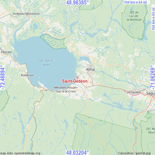
Saint-Gédéon GPS coordinates[2]
48° 30' 0.324" North, 71° 45' 56.916" West
| Map corner | latitude | longitude |
|---|---|---|
| Upper-left | 48.96385°, | -72.46894° |
| Center: | 48.50009°, | -71.76581° |
| Lower-right: | 48.03204°, | -71.06269° |
| Map W x H: | 103.6×103.6 km | = 64.4×64.4mi |
| max Lat: | 73.03752° ⇑42.2% North |
| Saint-Gédéon: | 48.50009° |
| min Lat: | ⇓57.8% South 42.05009° |
| min Long | Saint-Gédéon | max Long |
| -139.43328° | -71.76581° | -52.70931° |
| W 77.9%⇐ | ⇒22.1% E |
Elevation
Elevation of Saint-Gédéon is 112 m = 367 ft, and this is 142.4 m = 467 ft below average elevation for this country.
| Max E: |
1518 m = 4980 ft | 58.2% |
| Avg. | 254.4 m = 835 ft | |
| Saint-Gédéon | 112 m = 367 ft | |
Min E: |
-2 m = -7 ft | 41.8% |
See also: Canada elevation on elevation.city.
Geographical zone
Saint-Gédéon is located in North temperate zone (between Tropic of Cancer and the Arctic Circle). Distance of this North polar circle is 2008.5 km =1248 mi to North.| Distance of | km | miles | from Saint-Gédéon |
|---|---|---|---|
| North Pole | 4614.4 | 2867.3 | to North |
| Arctic Circle | 2008.5 | 1248 | to North |
| Tropic Cancer | 2786.8 | 1731.6 | to South |
| Equator | 5392.7 | 3350.9 | to South |


Nearby cities:
15 places around Saint-Gédéon: (largest is in red/bold)
• Alma
10.2 km =6.3 mi,  57°
57°
• Chambord
23.3 km =14.5 mi,  251°
251°
• Jonquière
39.2 km =24.4 mi,  103°
103°
• L'Ascension-de-Notre-Seigneur
21.7 km =13.5 mi,  19°
19°
• Metabetchouan-Lac-a-la-Croix
10.1 km =6.3 mi,  185°
185°
• Métabetchouan
23.7 km =14.7 mi,  231°
231°
• Pointe-du-Lac
1.2 km =0.7 mi,  270°
270°
• Pont Rouge
48.5 km =30.1 mi,  331°
331°
• Roberval
34.4 km =21.4 mi, 273°
• Saint-Ambroise
32.4 km =20.1 mi,  80°
80°
• Saint-Bruno
9.4 km =5.8 mi,  113°
113°
• Saint-Charles-de-Bourget
30.4 km =18.9 mi, 75°
• Saint-Honoré
50.5 km =31.4 mi,  85°
85°
• Saint-Nazaire
18.6 km =11.6 mi, 57°
• Saint-Prime
42.7 km =26.5 mi,  282°
282°
Sources, notices
• [Note1] Compared only with cities in Canada existing in our database
• [Src1] Map data: © OpenStreetMap contributors (CC-BY-SA)
• [Src2] Other city data from geonames.org with taken over terms of usage.
• [Src3] Geographical zone / Annual Mean Temperature by Robert A. Rohde @ Wikipedia
