Aldouane geodata
Aldouane (New Brunswick) is a populated place; located in Canada in America/Moncton (GMT-3) time zone. With population of 895 people, there are 1078 cities with bigger population in this country. Compared to other cities in Canada, 54.5% of cities are located further ↑North; 89.9% of cities are located further ←West and 77.1% of cities have higher elevation than Aldouane. Note1


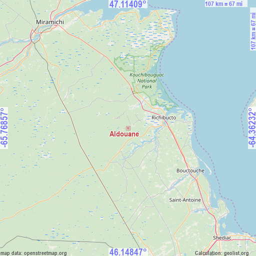
Aldouane GPS coordinates[2]
46° 38' 0.348" North, 65° 3' 55.584" West
| Map corner | latitude | longitude |
|---|---|---|
| Upper-left | 47.11409°, | -65.76857° |
| Center: | 46.63343°, | -65.06544° |
| Lower-right: | 46.14847°, | -64.36232° |
| Map W x H: | 107.4×107.4 km | = 66.7×66.7mi |
| max Lat: | 73.03752° ⇑54.5% North |
| Aldouane: | 46.63343° |
| min Lat: | ⇓45.5% South 42.05009° |
| min Long | Aldouane | max Long |
| -139.43328° | -65.06544° | -52.70931° |
| W 89.9%⇐ | ⇒10.1% E |
Elevation
Elevation of Aldouane is 38 m = 125 ft, and this is 216.4 m = 710 ft below average elevation for this country.
| Max E: |
1518 m = 4980 ft | 77.1% |
| Avg. | 254.4 m = 835 ft | |
| Aldouane | 38 m = 125 ft | |
Min E: |
-2 m = -7 ft | 22.9% |
See also: Canada elevation on elevation.city.
Geographical zone
Aldouane is located in North temperate zone (between Tropic of Cancer and the Arctic Circle). Distance of this North polar circle is 2216 km =1377 mi to North.| Distance of | km | miles | from Aldouane |
|---|---|---|---|
| North Pole | 4821.9 | 2996.2 | to North |
| Arctic Circle | 2216 | 1377 | to North |
| Tropic Cancer | 2579.2 | 1602.6 | to South |
| Equator | 5185.2 | 3221.9 | to South |


Nearby cities:
15 places around Aldouane: (largest is in red/bold)
• Baie Ste. Anne
47.3 km =29.4 mi,  10°
10°
• Bouctouche
31 km =19.3 mi,  126°
126°
• Evergreen Park
59.9 km =37.2 mi,  165°
165°
• Grande-Digue
53.3 km =33.1 mi, 134°
• Lutes Mountain
56.7 km =35.2 mi, 167°
• McEwen
58.4 km =36.3 mi,  158°
158°
• Miramichi
55.1 km =34.2 mi,  322°
322°
• Moncton
63.4 km =39.4 mi, 160°
• Richibucto
15.1 km =9.4 mi,  69°
69°
• Saint-Antoine
38.6 km =24 mi,  141°
141°
• Saint-Ignace
7.5 km =4.7 mi,  350°
350°
• Salisbury
66.1 km =41.1 mi,  178°
178°
• Shediac
61.1 km =38 mi, 138°
• Shediac Bridge-Shediac River
54 km =33.6 mi, 138°
• Shediac Cape
58.7 km =36.5 mi, 139°
Sources, notices
• [Note1] Compared only with cities in Canada existing in our database
• [Src1] Map data: © OpenStreetMap contributors (CC-BY-SA)
• [Src2] Other city data from geonames.org with taken over terms of usage.
• [Src3] Geographical zone / Annual Mean Temperature by Robert A. Rohde @ Wikipedia
