Baie Ste. Anne geodata
Baie Ste. Anne (New Brunswick) is a populated place; located in Canada in America/Moncton (GMT-3) time zone. With population of 1,319 people, there are 912 cities with bigger population in this country. Compared to other cities in Canada, 51.5% of cities are located further ↑North; 90.5% of cities are located further ←West and 98.1% of cities have higher elevation than Baie Ste. Anne. Note1


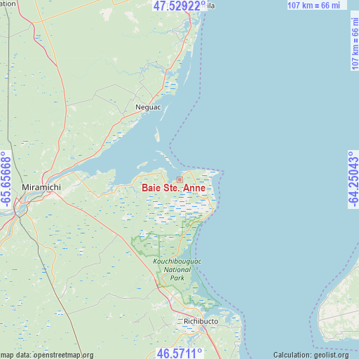
Baie Ste. Anne GPS coordinates[2]
47° 3' 8.316" North, 64° 57' 12.78" West
| Map corner | latitude | longitude |
|---|---|---|
| Upper-left | 47.52922°, | -65.65668° |
| Center: | 47.05231°, | -64.95355° |
| Lower-right: | 46.5711°, | -64.25043° |
| Map W x H: | 106.5×106.5 km | = 66.2×66.2mi |
| max Lat: | 73.03752° ⇑51.5% North |
| Baie Ste. Anne: | 47.05231° |
| min Lat: | ⇓48.5% South 42.05009° |
| min Long | Baie Ste. Anne | max Long |
| -139.43328° | -64.95355° | -52.70931° |
| W 90.5%⇐ | ⇒9.5% E |
Elevation
Elevation of Baie Ste. Anne is 3 m = 10 ft, and this is 251.4 m = 825 ft below average elevation for this country.
| Max E: |
1518 m = 4980 ft | 98.1% |
| Avg. | 254.4 m = 835 ft | |
| Baie Ste. Anne | 3 m = 10 ft | |
Min E: |
-2 m = -7 ft | 1.9% |
See also: Canada elevation on elevation.city.
Geographical zone
Baie Ste. Anne is located in North temperate zone (between Tropic of Cancer and the Arctic Circle). Distance of this North polar circle is 2169.4 km =1348 mi to North.| Distance of | km | miles | from Baie Ste. Anne |
|---|---|---|---|
| North Pole | 4775.3 | 2967.2 | to North |
| Arctic Circle | 2169.4 | 1348 | to North |
| Tropic Cancer | 2625.8 | 1631.6 | to South |
| Equator | 5231.7 | 3250.8 | to South |


Nearby cities:
15 places around Baie Ste. Anne: (largest is in red/bold)
• Alberton
72.3 km =44.9 mi,  111°
111°
• Aldouane
47.3 km =29.4 mi,  190°
190°
• Bouctouche
66.9 km =41.6 mi,  165°
165°
• Brantville
35.3 km =21.9 mi,  357°
357°
• Fair Isle
28.3 km =17.6 mi,  332°
332°
• Leech
44.6 km =27.7 mi, 357°
• Miramichi
41.6 km =25.8 mi,  266°
266°
• Richibucto
41.7 km =25.9 mi, 172°
• Saint Irénée and Alderwood
49.7 km =30.9 mi, 357°
• Saint-Ignace
40.4 km =25.1 mi, 194°
• Saint-Sauveur
58.2 km =36.2 mi,  335°
335°
• Saumarez
49.8 km =30.9 mi,  1°
1°
• Sunny Corner
66.7 km =41.4 mi,  258°
258°
• Tabusintac
30.9 km =19.2 mi,  351°
351°
• Tracadie-Sheila
51.5 km =32 mi, 2°
Sources, notices
• [Note1] Compared only with cities in Canada existing in our database
• [Src1] Map data: © OpenStreetMap contributors (CC-BY-SA)
• [Src2] Other city data from geonames.org with taken over terms of usage.
• [Src3] Geographical zone / Annual Mean Temperature by Robert A. Rohde @ Wikipedia
