Saint-Ignace geodata
Saint-Ignace (New Brunswick) is a populated place; located in Canada in America/Moncton (GMT-3) time zone. With population of 567 people, there are 1159 cities with bigger population in this country. Compared to other cities in Canada, 53.4% of cities are located further ↑North; 89.7% of cities are located further ←West and 88.3% of cities have higher elevation than Saint-Ignace. Note1


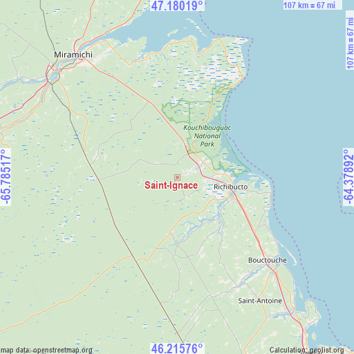
Saint-Ignace GPS coordinates[2]
46° 42' 0.468" North, 65° 4' 55.344" West
| Map corner | latitude | longitude |
|---|---|---|
| Upper-left | 47.18019°, | -65.78517° |
| Center: | 46.70013°, | -65.08204° |
| Lower-right: | 46.21576°, | -64.37892° |
| Map W x H: | 107.2×107.2 km | = 66.6×66.6mi |
| max Lat: | 73.03752° ⇑53.4% North |
| Saint-Ignace: | 46.70013° |
| min Lat: | ⇓46.6% South 42.05009° |
| min Long | Saint-Ignace | max Long |
| -139.43328° | -65.08204° | -52.70931° |
| W 89.7%⇐ | ⇒10.3% E |
Elevation
Elevation of Saint-Ignace is 17 m = 56 ft, and this is 237.4 m = 779 ft below average elevation for this country.
| Max E: |
1518 m = 4980 ft | 88.3% |
| Avg. | 254.4 m = 835 ft | |
| Saint-Ignace | 17 m = 56 ft | |
Min E: |
-2 m = -7 ft | 11.7% |
See also: Canada elevation on elevation.city.
Geographical zone
Saint-Ignace is located in North temperate zone (between Tropic of Cancer and the Arctic Circle). Distance of this North polar circle is 2208.6 km =1372.4 mi to North.| Distance of | km | miles | from Saint-Ignace |
|---|---|---|---|
| North Pole | 4814.5 | 2991.6 | to North |
| Arctic Circle | 2208.6 | 1372.4 | to North |
| Tropic Cancer | 2586.6 | 1607.2 | to South |
| Equator | 5192.6 | 3226.5 | to South |


Nearby cities:
15 places around Saint-Ignace: (largest is in red/bold)
• Aldouane
7.5 km =4.7 mi,  170°
170°
• Baie Ste. Anne
40.4 km =25.1 mi,  14°
14°
• Bouctouche
36.8 km =22.9 mi,  134°
134°
• Evergreen Park
67.4 km =41.9 mi, 165°
• Fair Isle
64.4 km =40 mi,  357°
357°
• Grande-Digue
59.5 km =37 mi,  138°
138°
• Lutes Mountain
64.2 km =39.9 mi, 167°
• McEwen
65.7 km =40.8 mi,  159°
159°
• Miramichi
48.5 km =30.1 mi,  318°
318°
• Richibucto
15.5 km =9.6 mi,  97°
97°
• Saint-Antoine
45.3 km =28.1 mi,  145°
145°
• Shediac
67.6 km =42 mi, 142°
• Shediac Bridge-Shediac River
60.5 km =37.6 mi, 142°
• Shediac Cape
65.3 km =40.6 mi, 142°
• Sunny Corner
61.5 km =38.2 mi,  294°
294°
Sources, notices
• [Note1] Compared only with cities in Canada existing in our database
• [Src1] Map data: © OpenStreetMap contributors (CC-BY-SA)
• [Src2] Other city data from geonames.org with taken over terms of usage.
• [Src3] Geographical zone / Annual Mean Temperature by Robert A. Rohde @ Wikipedia
