Armstrong geodata
Armstrong (British Columbia) is a populated place; located in Canada in America/Vancouver (GMT-7) time zone. With population of 4,275 people, there are 511 cities with bigger population in this country. Compared to other cities in Canada, 79% of cities are located further ↓South; 87.5% of cities are located further →East and 74.9% of cities have lower elevation than Armstrong. Note1
Administrative division(s):
- Level 1: British Columbia
- Level 2: Regional District of North Okanagan
- Level 3: Armstrong


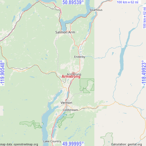
Armstrong GPS coordinates[2]
50° 26' 59.244" North, 119° 12' 8.46" West
| Map corner | latitude | longitude |
|---|---|---|
| Upper-left | 50.89539°, | -119.90548° |
| Center: | 50.44979°, | -119.20235° |
| Lower-right: | 49.99995°, | -118.49923° |
| Map W x H: | 99.6×99.6 km | = 61.9×61.9mi |
| max Lat: | 73.03752° ⇑21% North |
| Armstrong: | 50.44979° |
| min Lat: | ⇓79% South 42.05009° |
| min Long | Armstrong | max Long |
| -139.43328° | -119.20235° | -52.70931° |
| W 12.5%⇐ | ⇒87.5% E |
Elevation
Elevation of Armstrong is 359 m = 1178 ft, and this is 104.6 m = 343 ft above average elevation for this country.
| Max E: |
1518 m = 4980 ft | 25.1% |
| Armstrong | 359 m 1178 ft | |
| Avg. | 254.4 m = 835 ft | |
Min E: |
-2 m = -7 ft | 74.9% |
See also: Canada elevation on elevation.city.
Geographical zone
Armstrong is located in North temperate zone (between Tropic of Cancer and the Arctic Circle). Distance of this North polar circle is 1791.7 km =1113.3 mi to North.| Distance of | km | miles | from Armstrong |
|---|---|---|---|
| North Pole | 4397.6 | 2732.5 | to North |
| Arctic Circle | 1791.7 | 1113.3 | to North |
| Tropic Cancer | 3003.6 | 1866.3 | to South |
| Equator | 5609.5 | 3485.6 | to South |


Nearby cities:
15 places around Armstrong: (largest is in red/bold)
• Chase
53.1 km =33 mi,  320°
320°
• Duck Lake
50.9 km =31.6 mi,  195°
195°
• Ellison
58.7 km =36.5 mi,  191°
191°
• Enderby
11.7 km =7.3 mi,  17°
17°
• Falkland
25.4 km =15.8 mi,  282°
282°
• Kelowna
66.2 km =41.1 mi, 197°
• Lumby
27.7 km =17.2 mi,  143°
143°
• Okanagan
14.2 km =8.8 mi,  227°
227°
• Ranchero
22.7 km =14.1 mi,  359°
359°
• Salmon Arm
28.7 km =17.8 mi,  345°
345°
• Scotch Creek
53 km =32.9 mi,  340°
340°
• Sicamous
45.3 km =28.1 mi, 19°
• Sunnybrae
35.5 km =22.1 mi, 352°
• Vernon
20.9 km =13 mi, 193°
• White Lake
48.7 km =30.3 mi, 351°
Sources, notices
• [Note1] Compared only with cities in Canada existing in our database
• [Src1] Map data: © OpenStreetMap contributors (CC-BY-SA)
• [Src2] Other city data from geonames.org with taken over terms of usage.
• [Src3] Geographical zone / Annual Mean Temperature by Robert A. Rohde @ Wikipedia
