Falkland geodata
Falkland (British Columbia) is a populated place; located in Canada in America/Vancouver (GMT-7) time zone. With population of 878 people, there are 1081 cities with bigger population in this country. Compared to other cities in Canada, 79.4% of cities are located further ↓South; 88.6% of cities are located further →East and 86.6% of cities have lower elevation than Falkland. Note1


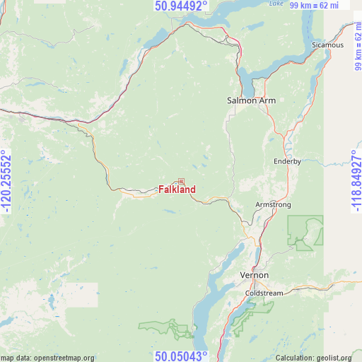
Falkland GPS coordinates[2]
50° 29' 59.244" North, 119° 33' 8.604" West
| Map corner | latitude | longitude |
|---|---|---|
| Upper-left | 50.94492°, | -120.25552° |
| Center: | 50.49979°, | -119.55239° |
| Lower-right: | 50.05043°, | -118.84927° |
| Map W x H: | 99.5×99.5 km | = 61.8×61.8mi |
| max Lat: | 73.03752° ⇑20.6% North |
| Falkland: | 50.49979° |
| min Lat: | ⇓79.4% South 42.05009° |
| min Long | Falkland | max Long |
| -139.43328° | -119.55239° | -52.70931° |
| W 11.4%⇐ | ⇒88.6% E |
Elevation
Elevation of Falkland is 598 m = 1962 ft, and this is 343.6 m = 1127 ft above average elevation for this country.
| Max E: |
1518 m = 4980 ft | 13.4% |
| Falkland | 598 m 1962 ft | |
| Avg. | 254.4 m = 835 ft | |
Min E: |
-2 m = -7 ft | 86.6% |
See also: Canada elevation on elevation.city.
Geographical zone
Falkland is located in North temperate zone (between Tropic of Cancer and the Arctic Circle). Distance of this North polar circle is 1786.1 km =1109.8 mi to North.| Distance of | km | miles | from Falkland |
|---|---|---|---|
| North Pole | 4392 | 2729.1 | to North |
| Arctic Circle | 1786.1 | 1109.8 | to North |
| Tropic Cancer | 3009.1 | 1869.8 | to South |
| Equator | 5615.1 | 3489.1 | to South |


Nearby cities:
15 places around Falkland: (largest is in red/bold)
• Armstrong
25.4 km =15.8 mi,  102°
102°
• Chase
36.4 km =22.6 mi,  345°
345°
• Duck Lake
55.7 km =34.6 mi,  168°
168°
• Ellison
64.3 km =40 mi, 168°
• Enderby
28.8 km =17.9 mi,  78°
78°
• Kamloops
57.2 km =35.5 mi,  288°
288°
• Lumby
49.8 km =30.9 mi,  123°
123°
• Okanagan
20.8 km =12.9 mi,  136°
136°
• Ranchero
30.1 km =18.7 mi,  55°
55°
• Salmon Arm
28.4 km =17.6 mi,  38°
38°
• Scotch Creek
45 km =28 mi,  8°
8°
• Sicamous
54.5 km =33.9 mi,  47°
47°
• Sunnybrae
35.8 km =22.2 mi,  33°
33°
• Vernon
32.6 km =20.3 mi, 142°
• White Lake
46.1 km =28.6 mi,  22°
22°
Sources, notices
• [Note1] Compared only with cities in Canada existing in our database
• [Src1] Map data: © OpenStreetMap contributors (CC-BY-SA)
• [Src2] Other city data from geonames.org with taken over terms of usage.
• [Src3] Geographical zone / Annual Mean Temperature by Robert A. Rohde @ Wikipedia
