Scotch Creek geodata
Scotch Creek (British Columbia) is a populated place; located in Canada in America/Vancouver (GMT-7) time zone. With population of 711 people, there are 1119 cities with bigger population in this country. Compared to other cities in Canada, 81.8% of cities are located further ↓South; 88.4% of cities are located further →East and 74.2% of cities have lower elevation than Scotch Creek. Note1


Scotch Creek GPS coordinates[2]
50° 53' 59.316" North, 119° 27' 8.64" West
| Map corner | latitude | longitude |
|---|---|---|
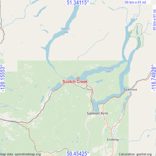
| Upper-left | 51.34115°, | -120.15553° |
| Center: | 50.89981°, | -119.4524° |
| Lower-right: | 50.45425°, | -118.74928° |
| Map W x H: | 98.6×98.6 km | = 61.3×61.3mi |
| max Lat: | 73.03752° ⇑18.2% North |
| Scotch Creek: | 50.89981° |
| min Lat: | ⇓81.8% South 42.05009° |
| min Long | Scotch Creek | max Long |
| -139.43328° | -119.4524° | -52.70931° |
| W 11.6%⇐ | ⇒88.4% E |
Elevation
Elevation of Scotch Creek is 350 m = 1148 ft, and this is 95.6 m = 314 ft above average elevation for this country.
| Max E: |
1518 m = 4980 ft | 25.8% |
| Scotch Creek | 350 m 1148 ft | |
| Avg. | 254.4 m = 835 ft | |
Min E: |
-2 m = -7 ft | 74.2% |
See also: Canada elevation on elevation.city.
Geographical zone
Scotch Creek is located in North temperate zone (between Tropic of Cancer and the Arctic Circle). Distance of this North polar circle is 1741.6 km =1082.2 mi to North.| Distance of | km | miles | from Scotch Creek |
|---|---|---|---|
| North Pole | 4347.5 | 2701.4 | to North |
| Arctic Circle | 1741.6 | 1082.2 | to North |
| Tropic Cancer | 3053.6 | 1897.4 | to South |
| Equator | 5659.5 | 3516.6 | to South |


Nearby cities:
15 places around Scotch Creek: (largest is in red/bold)
• Armstrong
53 km =32.9 mi,  160°
160°
• Barrière
56.3 km =35 mi,  304°
304°
• Chase
18.8 km =11.7 mi,  240°
240°
• Enderby
44.3 km =27.5 mi,  151°
151°
• Falkland
45 km =28 mi,  188°
188°
• Kamloops
66.2 km =41.1 mi,  246°
246°
• Lumby
79.9 km =49.6 mi, 154°
• Okanagan
60 km =37.3 mi,  173°
173°
• Ranchero
32.5 km =20.2 mi, 147°
• Revelstoke
88.7 km =55.1 mi,  82°
82°
• Salmon Arm
24.6 km =15.3 mi, 154°
• Sicamous
33.6 km =20.9 mi,  102°
102°
• Sunnybrae
19.6 km =12.2 mi,  139°
139°
• Vernon
71.5 km =44.4 mi, 169°
• White Lake
10.7 km =6.6 mi, 100°
Sources, notices
• [Note1] Compared only with cities in Canada existing in our database
• [Src1] Map data: © OpenStreetMap contributors (CC-BY-SA)
• [Src2] Other city data from geonames.org with taken over terms of usage.
• [Src3] Geographical zone / Annual Mean Temperature by Robert A. Rohde @ Wikipedia
