Ranchero geodata
Ranchero (British Columbia) is a populated place; located in Canada in America/Vancouver (GMT-7) time zone. With population of 959 people, there are 1062 cities with bigger population in this country. Compared to other cities in Canada, 80.5% of cities are located further ↓South; 87.5% of cities are located further →East and 83.1% of cities have lower elevation than Ranchero. Note1


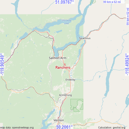
Ranchero GPS coordinates[2]
50° 39' 14.4" North, 119° 12' 8.496" West
| Map corner | latitude | longitude |
|---|---|---|
| Upper-left | 51.09767°, | -119.90549° |
| Center: | 50.654°, | -119.20236° |
| Lower-right: | 50.2061°, | -118.49924° |
| Map W x H: | 99.1×99.1 km | = 61.6×61.6mi |
| max Lat: | 73.03752° ⇑19.5% North |
| Ranchero: | 50.654° |
| min Lat: | ⇓80.5% South 42.05009° |
| min Long | Ranchero | max Long |
| -139.43328° | -119.20236° | -52.70931° |
| W 12.5%⇐ | ⇒87.5% E |
Elevation
Elevation of Ranchero is 524 m = 1719 ft, and this is 269.6 m = 885 ft above average elevation for this country.
| Max E: |
1518 m = 4980 ft | 16.9% |
| Ranchero | 524 m 1719 ft | |
| Avg. | 254.4 m = 835 ft | |
Min E: |
-2 m = -7 ft | 83.1% |
See also: Canada elevation on elevation.city.
Geographical zone
Ranchero is located in North temperate zone (between Tropic of Cancer and the Arctic Circle). Distance of this North polar circle is 1769 km =1099.2 mi to North.| Distance of | km | miles | from Ranchero |
|---|---|---|---|
| North Pole | 4374.9 | 2718.4 | to North |
| Arctic Circle | 1769 | 1099.2 | to North |
| Tropic Cancer | 3026.3 | 1880.5 | to South |
| Equator | 5632.2 | 3499.7 | to South |


Nearby cities:
15 places around Ranchero: (largest is in red/bold)
• Armstrong
22.7 km =14.1 mi,  179°
179°
• Chase
38.5 km =23.9 mi,  297°
297°
• Duck Lake
73.1 km =45.4 mi,  190°
190°
• Enderby
12.1 km =7.5 mi,  163°
163°
• Falkland
30.1 km =18.7 mi,  235°
235°
• Kamloops
78.7 km =48.9 mi,  271°
271°
• Lumby
47.9 km =29.8 mi, 159°
• Okanagan
33.9 km =21.1 mi,  197°
197°
• Revelstoke
80.4 km =50 mi,  61°
61°
• Salmon Arm
8.7 km =5.4 mi,  305°
305°
• Scotch Creek
32.5 km =20.2 mi,  327°
327°
• Sicamous
25.1 km =15.6 mi,  37°
37°
• Sunnybrae
13.4 km =8.3 mi,  339°
339°
• Vernon
43.3 km =26.9 mi, 186°
• White Lake
26.4 km =16.4 mi, 344°
Sources, notices
• [Note1] Compared only with cities in Canada existing in our database
• [Src1] Map data: © OpenStreetMap contributors (CC-BY-SA)
• [Src2] Other city data from geonames.org with taken over terms of usage.
• [Src3] Geographical zone / Annual Mean Temperature by Robert A. Rohde @ Wikipedia
