Sunnybrae geodata
Sunnybrae (British Columbia) is a populated place; located in Canada in America/Vancouver (GMT-7) time zone. With population of 610 people, there are 1145 cities with bigger population in this country. Compared to other cities in Canada, 81.1% of cities are located further ↓South; 87.6% of cities are located further →East and 73.9% of cities have lower elevation than Sunnybrae. Note1


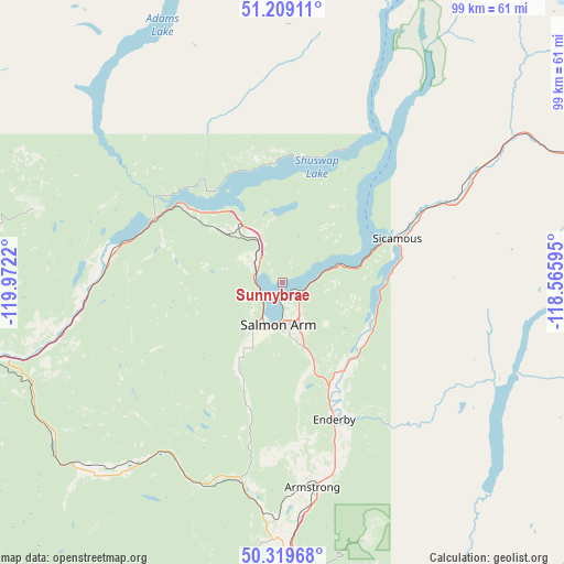
Sunnybrae GPS coordinates[2]
50° 45' 59.436" North, 119° 16' 8.652" West
| Map corner | latitude | longitude |
|---|---|---|
| Upper-left | 51.20911°, | -119.9722° |
| Center: | 50.76651°, | -119.26907° |
| Lower-right: | 50.31968°, | -118.56595° |
| Map W x H: | 98.9×98.9 km | = 61.5×61.5mi |
| max Lat: | 73.03752° ⇑18.9% North |
| Sunnybrae: | 50.76651° |
| min Lat: | ⇓81.1% South 42.05009° |
| min Long | Sunnybrae | max Long |
| -139.43328° | -119.26907° | -52.70931° |
| W 12.4%⇐ | ⇒87.6% E |
Elevation
Elevation of Sunnybrae is 348 m = 1142 ft, and this is 93.6 m = 307 ft above average elevation for this country.
| Max E: |
1518 m = 4980 ft | 26.1% |
| Sunnybrae | 348 m 1142 ft | |
| Avg. | 254.4 m = 835 ft | |
Min E: |
-2 m = -7 ft | 73.9% |
See also: Canada elevation on elevation.city.
Geographical zone
Sunnybrae is located in North temperate zone (between Tropic of Cancer and the Arctic Circle). Distance of this North polar circle is 1756.5 km =1091.4 mi to North.| Distance of | km | miles | from Sunnybrae |
|---|---|---|---|
| North Pole | 4362.4 | 2710.7 | to North |
| Arctic Circle | 1756.5 | 1091.4 | to North |
| Tropic Cancer | 3038.8 | 1888.2 | to South |
| Equator | 5644.7 | 3507.5 | to South |


Nearby cities:
15 places around Sunnybrae: (largest is in red/bold)
• Armstrong
35.5 km =22.1 mi,  172°
172°
• Barrière
75.4 km =46.9 mi,  307°
307°
• Chase
29.8 km =18.5 mi,  280°
280°
• Enderby
25.5 km =15.8 mi,  161°
161°
• Falkland
35.8 km =22.2 mi,  213°
213°
• Kamloops
74.8 km =46.5 mi,  261°
261°
• Lumby
61.2 km =38 mi, 159°
• Okanagan
45.1 km =28 mi,  187°
187°
• Ranchero
13.4 km =8.3 mi, 159°
• Revelstoke
79.6 km =49.5 mi,  71°
71°
• Salmon Arm
7.8 km =4.8 mi,  197°
197°
• Scotch Creek
19.6 km =12.2 mi,  319°
319°
• Sicamous
21.2 km =13.2 mi, 69°
• Vernon
55.5 km =34.5 mi,  180°
180°
• White Lake
13.2 km =8.2 mi,  349°
349°
Sources, notices
• [Note1] Compared only with cities in Canada existing in our database
• [Src1] Map data: © OpenStreetMap contributors (CC-BY-SA)
• [Src2] Other city data from geonames.org with taken over terms of usage.
• [Src3] Geographical zone / Annual Mean Temperature by Robert A. Rohde @ Wikipedia
