Bath geodata
Bath (Ontario) is a populated place; located in Canada in America/Toronto (GMT-4) time zone. With population of 1,180 people, there are 959 cities with bigger population in this country. Compared to other cities in Canada, 90% of cities are located further ↑North; 53.7% of cities are located further ←West and 64.5% of cities have higher elevation than Bath. Note1


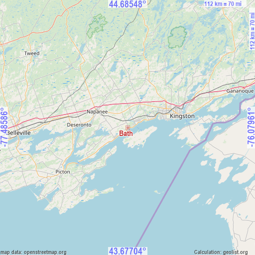
Bath GPS coordinates[2]
44° 11' 0.312" North, 76° 46' 57.828" West
| Map corner | latitude | longitude |
|---|---|---|
| Upper-left | 44.68548°, | -77.48586° |
| Center: | 44.18342°, | -76.78273° |
| Lower-right: | 43.67704°, | -76.07961° |
| Map W x H: | 112.1×112.1 km | = 69.7×69.7mi |
| max Lat: | 73.03752° ⇑90% North |
| Bath: | 44.18342° |
| min Lat: | ⇓10% South 42.05009° |
| min Long | Bath | max Long |
| -139.43328° | -76.78273° | -52.70931° |
| W 53.7%⇐ | ⇒46.3% E |
Elevation
Elevation of Bath is 79 m = 259 ft, and this is 175.4 m = 575 ft below average elevation for this country.
| Max E: |
1518 m = 4980 ft | 64.5% |
| Avg. | 254.4 m = 835 ft | |
| Bath | 79 m = 259 ft | |
Min E: |
-2 m = -7 ft | 35.5% |
See also: Canada elevation on elevation.city.
Geographical zone
Bath is located in North temperate zone (between Tropic of Cancer and the Arctic Circle). Distance of this Northern Tropic circle is 2306.8 km =1433.4 mi to South.| Distance of | km | miles | from Bath |
|---|---|---|---|
| North Pole | 5094.3 | 3165.5 | to North |
| Arctic Circle | 2488.4 | 1546.2 | to North |
| Tropic Cancer | 2306.8 | 1433.4 | to South |
| Equator | 4912.7 | 3052.6 | to South |


Nearby cities:
15 places around Bath: (largest is in red/bold)
• Athens
83 km =51.6 mi,  52°
52°
• Belleville
47.9 km =29.8 mi,  267°
267°
• Deseronto
21.3 km =13.2 mi, 274°
• Gananoque
51.9 km =32.2 mi,  71°
71°
• Greater Napanee
15.2 km =9.4 mi,  299°
299°
• Kingston
24.6 km =15.3 mi,  77°
77°
• Madoc
65.8 km =40.9 mi, 303°
• Napanee
15.2 km =9.4 mi, 299°
• Napanee Downtown
15.2 km =9.4 mi, 298°
• Picton
34.6 km =21.5 mi,  233°
233°
• Prince Edward
42.5 km =26.4 mi,  241°
241°
• Quinte West
62.5 km =38.8 mi, 270°
• Skatepark
14.9 km =9.3 mi, 300°
• Stirling
62.4 km =38.8 mi,  281°
281°
• Tweed
53.4 km =33.2 mi,  307°
307°
Sources, notices
• [Note1] Compared only with cities in Canada existing in our database
• [Src1] Map data: © OpenStreetMap contributors (CC-BY-SA)
• [Src2] Other city data from geonames.org with taken over terms of usage.
• [Src3] Geographical zone / Annual Mean Temperature by Robert A. Rohde @ Wikipedia
