Belleville geodata
Belleville (Ontario) is a populated place; located in Canada in America/Toronto (GMT-4) time zone. With population of 49,454 people, there are 102 cities with bigger population in this country. Compared to other cities in Canada, 90.2% of cities are located further ↑North; 52.6% of cities are located further ←West and 61.1% of cities have higher elevation than Belleville. Note1


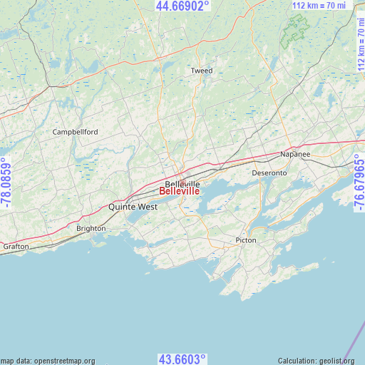
Belleville GPS coordinates[2]
44° 10' 0.552" North, 77° 22' 57.972" West
| Map corner | latitude | longitude |
|---|---|---|
| Upper-left | 44.66902°, | -78.0859° |
| Center: | 44.16682°, | -77.38277° |
| Lower-right: | 43.6603°, | -76.67965° |
| Map W x H: | 112.2×112.2 km | = 69.7×69.7mi |
| max Lat: | 73.03752° ⇑90.2% North |
| Belleville: | 44.16682° |
| min Lat: | ⇓9.8% South 42.05009° |
| min Long | Belleville | max Long |
| -139.43328° | -77.38277° | -52.70931° |
| W 52.6%⇐ | ⇒47.4% E |
Elevation
Elevation of Belleville is 93 m = 305 ft, and this is 161.4 m = 530 ft below average elevation for this country.
| Max E: |
1518 m = 4980 ft | 61.1% |
| Avg. | 254.4 m = 835 ft | |
| Belleville | 93 m = 305 ft | |
Min E: |
-2 m = -7 ft | 38.9% |
See also: Belleville elevation on elevation.city.
Geographical zone
Belleville is located in North temperate zone (between Tropic of Cancer and the Arctic Circle). Distance of this Northern Tropic circle is 2305 km =1432.3 mi to South.| Distance of | km | miles | from Belleville |
|---|---|---|---|
| North Pole | 5096.2 | 3166.6 | to North |
| Arctic Circle | 2490.3 | 1547.4 | to North |
| Tropic Cancer | 2305 | 1432.3 | to South |
| Equator | 4910.9 | 3051.5 | to South |


Nearby cities:
15 places around Belleville: (largest is in red/bold)
• Bath
47.9 km =29.8 mi,  87°
87°
• Cobourg
66.6 km =41.4 mi,  249°
249°
• Deseronto
26.8 km =16.7 mi,  82°
82°
• Greater Napanee
35.8 km =22.2 mi,  74°
74°
• Kingston
72.2 km =44.9 mi, 84°
• Madoc
38.7 km =24 mi,  349°
349°
• Napanee
35.8 km =22.2 mi, 74°
• Napanee Downtown
35.6 km =22.1 mi, 75°
• Norwood
53.5 km =33.2 mi,  296°
296°
• Picton
27.2 km =16.9 mi,  132°
132°
• Prince Edward
21.4 km =13.3 mi,  150°
150°
• Quinte West
14.7 km =9.1 mi,  277°
277°
• Skatepark
36.2 km =22.5 mi, 74°
• Stirling
19.9 km =12.4 mi,  318°
318°
• Tweed
34.7 km =21.6 mi,  8°
8°
Sources, notices
• [Note1] Compared only with cities in Canada existing in our database
• [Src1] Map data: © OpenStreetMap contributors (CC-BY-SA)
• [Src2] Other city data from geonames.org with taken over terms of usage.
• [Src3] Geographical zone / Annual Mean Temperature by Robert A. Rohde @ Wikipedia
