Prince Edward geodata
Prince Edward (Ontario) is a populated place; located in Canada in America/Toronto (GMT-4) time zone. With population of 25,496 people, there are 159 cities with bigger population in this country. Compared to other cities in Canada, 91.8% of cities are located further ↑North; 52.9% of cities are located further ←West and 60.2% of cities have higher elevation than Prince Edward. Note1


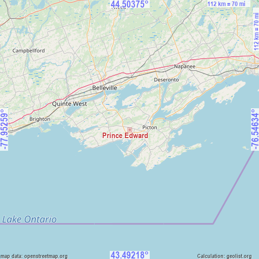
Prince Edward GPS coordinates[2]
44° 0' 0.432" North, 77° 14' 58.056" West
| Map corner | latitude | longitude |
|---|---|---|
| Upper-left | 44.50375°, | -77.95259° |
| Center: | 44.00012°, | -77.24946° |
| Lower-right: | 43.49218°, | -76.54634° |
| Map W x H: | 112.5×112.5 km | = 69.9×69.9mi |
| max Lat: | 73.03752° ⇑91.8% North |
| Prince Edward: | 44.00012° |
| min Lat: | ⇓8.2% South 42.05009° |
| min Long | Prince Edward | max Long |
| -139.43328° | -77.24946° | -52.70931° |
| W 52.9%⇐ | ⇒47.1% E |
Elevation
Elevation of Prince Edward is 97 m = 318 ft, and this is 157.4 m = 516 ft below average elevation for this country.
| Max E: |
1518 m = 4980 ft | 60.2% |
| Avg. | 254.4 m = 835 ft | |
| Prince Edward | 97 m = 318 ft | |
Min E: |
-2 m = -7 ft | 39.8% |
See also: Canada elevation on elevation.city.
Geographical zone
Prince Edward is located in North temperate zone (between Tropic of Cancer and the Arctic Circle). Distance of this Northern Tropic circle is 2286.4 km =1420.7 mi to South.| Distance of | km | miles | from Prince Edward |
|---|---|---|---|
| North Pole | 5114.7 | 3178.1 | to North |
| Arctic Circle | 2508.8 | 1558.9 | to North |
| Tropic Cancer | 2286.4 | 1420.7 | to South |
| Equator | 4892.4 | 3040 | to South |


Nearby cities:
15 places around Prince Edward: (largest is in red/bold)
• Bath
42.5 km =26.4 mi,  61°
61°
• Belleville
21.4 km =13.3 mi,  330°
330°
• Cobourg
73.4 km =45.6 mi,  266°
266°
• Deseronto
27.4 km =17 mi,  35°
35°
• Greater Napanee
36.7 km =22.8 mi, 40°
• Kingston
66.4 km =41.3 mi,  67°
67°
• Madoc
59.3 km =36.8 mi,  342°
342°
• Napanee
36.7 km =22.8 mi, 40°
• Napanee Downtown
36.5 km =22.7 mi, 40°
• Norwood
72.4 km =45 mi,  306°
306°
• Picton
9.3 km =5.8 mi,  90°
90°
• Quinte West
32.5 km =20.2 mi, 308°
• Skatepark
37.1 km =23.1 mi, 41°
• Stirling
41.1 km =25.5 mi,  324°
324°
• Tweed
53.1 km =33 mi,  354°
354°
Sources, notices
• [Note1] Compared only with cities in Canada existing in our database
• [Src1] Map data: © OpenStreetMap contributors (CC-BY-SA)
• [Src2] Other city data from geonames.org with taken over terms of usage.
• [Src3] Geographical zone / Annual Mean Temperature by Robert A. Rohde @ Wikipedia
