Gananoque geodata
Gananoque (Ontario) is a populated place; located in Canada in America/Toronto (GMT-4) time zone. With population of 5,458 people, there are 454 cities with bigger population in this country. Compared to other cities in Canada, 88.5% of cities are located further ↑North; 54.3% of cities are located further ←West and 63.6% of cities have higher elevation than Gananoque. Note1


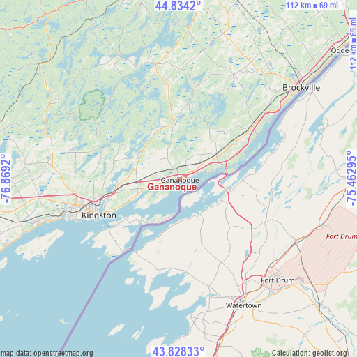
Gananoque GPS coordinates[2]
44° 20' 0.312" North, 76° 9' 57.852" West
| Map corner | latitude | longitude |
|---|---|---|
| Upper-left | 44.8342°, | -76.8692° |
| Center: | 44.33342°, | -76.16607° |
| Lower-right: | 43.82833°, | -75.46295° |
| Map W x H: | 111.8×111.8 km | = 69.5×69.5mi |
| max Lat: | 73.03752° ⇑88.5% North |
| Gananoque: | 44.33342° |
| min Lat: | ⇓11.5% South 42.05009° |
| min Long | Gananoque | max Long |
| -139.43328° | -76.16607° | -52.70931° |
| W 54.3%⇐ | ⇒45.7% E |
Elevation
Elevation of Gananoque is 84 m = 276 ft, and this is 170.4 m = 559 ft below average elevation for this country.
| Max E: |
1518 m = 4980 ft | 63.6% |
| Avg. | 254.4 m = 835 ft | |
| Gananoque | 84 m = 276 ft | |
Min E: |
-2 m = -7 ft | 36.4% |
See also: Canada elevation on elevation.city.
Geographical zone
Gananoque is located in North temperate zone (between Tropic of Cancer and the Arctic Circle). Distance of this Northern Tropic circle is 2323.5 km =1443.8 mi to South.| Distance of | km | miles | from Gananoque |
|---|---|---|---|
| North Pole | 5077.6 | 3155.1 | to North |
| Arctic Circle | 2471.8 | 1535.9 | to North |
| Tropic Cancer | 2323.5 | 1443.8 | to South |
| Equator | 4929.4 | 3063 | to South |


Nearby cities:
15 places around Gananoque: (largest is in red/bold)
• Athens
37.5 km =23.3 mi,  27°
27°
• Bath
51.9 km =32.2 mi,  251°
251°
• Brockville
47.6 km =29.6 mi,  52°
52°
• Carleton Place
89 km =55.3 mi,  0°
0°
• Deseronto
71.9 km =44.7 mi,  258°
258°
• Greater Napanee
63 km =39.1 mi, 261°
• Kingston
27.6 km =17.1 mi, 245°
• Napanee
63 km =39.1 mi, 261°
• Napanee Downtown
63.2 km =39.3 mi, 261°
• Perth
63.4 km =39.4 mi,  354°
354°
• Picton
85.5 km =53.1 mi,  244°
244°
• Prescott
66.9 km =41.6 mi, 50°
• Skatepark
62.6 km =38.9 mi, 261°
• Smiths Falls
64.5 km =40.1 mi,  10°
10°
• Tweed
92.7 km =57.6 mi,  279°
279°
Sources, notices
• [Note1] Compared only with cities in Canada existing in our database
• [Src1] Map data: © OpenStreetMap contributors (CC-BY-SA)
• [Src2] Other city data from geonames.org with taken over terms of usage.
• [Src3] Geographical zone / Annual Mean Temperature by Robert A. Rohde @ Wikipedia
