Kingston geodata
Kingston (Ontario) is a populated place; located in Canada in America/Toronto (GMT-4) time zone. With population of 114,195 people, there are 49 cities with bigger population in this country. Compared to other cities in Canada, 89.6% of cities are located further ↑North; 54% of cities are located further ←West and 63.6% of cities have higher elevation than Kingston. Note1


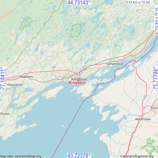
Kingston GPS coordinates[2]
44° 13' 47.136" North, 76° 28' 51.528" West
| Map corner | latitude | longitude |
|---|---|---|
| Upper-left | 44.73143°, | -77.18411° |
| Center: | 44.22976°, | -76.48098° |
| Lower-right: | 43.72378°, | -75.77786° |
| Map W x H: | 112×112 km | = 69.6×69.6mi |
| max Lat: | 73.03752° ⇑89.6% North |
| Kingston: | 44.22976° |
| min Lat: | ⇓10.4% South 42.05009° |
| min Long | Kingston | max Long |
| -139.43328° | -76.48098° | -52.70931° |
| W 54%⇐ | ⇒46% E |
Elevation
Elevation of Kingston is 83 m = 272 ft, and this is 171.4 m = 562 ft below average elevation for this country.
| Max E: |
1518 m = 4980 ft | 63.6% |
| Avg. | 254.4 m = 835 ft | |
| Kingston | 83 m = 272 ft | |
Min E: |
-2 m = -7 ft | 36.4% |
See also: Kingston elevation on elevation.city.
Geographical zone
Kingston is located in North temperate zone (between Tropic of Cancer and the Arctic Circle). Distance of this Northern Tropic circle is 2312 km =1436.6 mi to South.| Distance of | km | miles | from Kingston |
|---|---|---|---|
| North Pole | 5089.2 | 3162.3 | to North |
| Arctic Circle | 2483.3 | 1543.1 | to North |
| Tropic Cancer | 2312 | 1436.6 | to South |
| Equator | 4917.9 | 3055.8 | to South |


Nearby cities:
15 places around Kingston: (largest is in red/bold)
• Athens
61.6 km =38.3 mi,  43°
43°
• Bath
24.6 km =15.3 mi,  257°
257°
• Belleville
72.2 km =44.9 mi, 264°
• Brockville
74.8 km =46.5 mi,  57°
57°
• Deseronto
45.4 km =28.2 mi,  265°
265°
• Gananoque
27.6 km =17.1 mi,  65°
65°
• Greater Napanee
37.4 km =23.2 mi, 273°
• Napanee
37.4 km =23.2 mi, 273°
• Napanee Downtown
37.5 km =23.3 mi, 273°
• Perth
76.8 km =47.7 mi,  13°
13°
• Picton
58 km =36 mi,  243°
243°
• Prince Edward
66.4 km =41.3 mi,  247°
247°
• Skatepark
37 km =23 mi, 273°
• Smiths Falls
83.3 km =51.8 mi,  25°
25°
• Tweed
71.8 km =44.6 mi,  292°
292°
Sources, notices
• [Note1] Compared only with cities in Canada existing in our database
• [Src1] Map data: © OpenStreetMap contributors (CC-BY-SA)
• [Src2] Other city data from geonames.org with taken over terms of usage.
• [Src3] Geographical zone / Annual Mean Temperature by Robert A. Rohde @ Wikipedia
