Bedford geodata
Bedford (Quebec) is a populated place; located in Canada in America/Toronto (GMT-4) time zone. With population of 2,684 people, there are 651 cities with bigger population in this country. Compared to other cities in Canada, 83.2% of cities are located further ↑North; 72.4% of cities are located further ←West and 69.4% of cities have higher elevation than Bedford. Note1


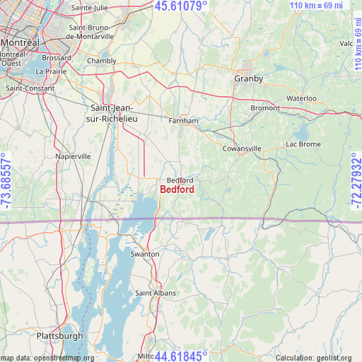
Bedford GPS coordinates[2]
45° 7' 0.408" North, 72° 58' 56.784" West
| Map corner | latitude | longitude |
|---|---|---|
| Upper-left | 45.61079°, | -73.68557° |
| Center: | 45.11678°, | -72.98244° |
| Lower-right: | 44.61845°, | -72.27932° |
| Map W x H: | 110.3×110.3 km | = 68.5×68.5mi |
| max Lat: | 73.03752° ⇑83.2% North |
| Bedford: | 45.11678° |
| min Lat: | ⇓16.8% South 42.05009° |
| min Long | Bedford | max Long |
| -139.43328° | -72.98244° | -52.70931° |
| W 72.4%⇐ | ⇒27.6% E |
Elevation
Elevation of Bedford is 57 m = 187 ft, and this is 197.4 m = 648 ft below average elevation for this country.
| Max E: |
1518 m = 4980 ft | 69.4% |
| Avg. | 254.4 m = 835 ft | |
| Bedford | 57 m = 187 ft | |
Min E: |
-2 m = -7 ft | 30.6% |
See also: Canada elevation on elevation.city.
Geographical zone
Bedford is located in North temperate zone (between Tropic of Cancer and the Arctic Circle). Distance of this North polar circle is 2384.7 km =1481.8 mi to North.| Distance of | km | miles | from Bedford |
|---|---|---|---|
| North Pole | 4990.5 | 3101 | to North |
| Arctic Circle | 2384.7 | 1481.8 | to North |
| Tropic Cancer | 2410.6 | 1497.9 | to South |
| Equator | 5016.5 | 3117.1 | to South |


Nearby cities:
15 places around Bedford: (largest is in red/bold)
• Ange-Gardien
26.2 km =16.3 mi,  8°
8°
• Bromont
34.3 km =21.3 mi,  49°
49°
• Cowansville
20.5 km =12.7 mi,  63°
63°
• Dunham
14.5 km =9 mi,  82°
82°
• Farnham
18.5 km =11.5 mi,  0°
0°
• Lacolle
30.3 km =18.8 mi,  262°
262°
• Mont-Saint-Grégoire
28 km =17.4 mi,  329°
329°
• Napierville
34 km =21.1 mi,  283°
283°
• Parc-Boutin
29.3 km =18.2 mi,  311°
311°
• Rougemont
35.6 km =22.1 mi,  351°
351°
• Saint-Césaire
33.4 km =20.8 mi,  357°
357°
• Saint-Jean-sur-Richelieu
30.5 km =19 mi, 313°
• Sainte-Croix
14.4 km =8.9 mi, 82°
• Sutton
28.8 km =17.9 mi,  93°
93°
• Venise-en-Québec
12.3 km =7.6 mi,  252°
252°
Sources, notices
• [Note1] Compared only with cities in Canada existing in our database
• [Src1] Map data: © OpenStreetMap contributors (CC-BY-SA)
• [Src2] Other city data from geonames.org with taken over terms of usage.
• [Src3] Geographical zone / Annual Mean Temperature by Robert A. Rohde @ Wikipedia
