Farnham geodata
Farnham (Quebec) is a populated place; located in Canada in America/Toronto (GMT-4) time zone. With population of 6,061 people, there are 429 cities with bigger population in this country. Compared to other cities in Canada, 81.4% of cities are located further ↑North; 72.4% of cities are located further ←West and 69.9% of cities have higher elevation than Farnham. Note1


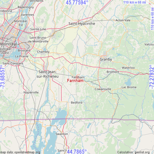
Farnham GPS coordinates[2]
45° 17' 0.168" North, 72° 58' 56.784" West
| Map corner | latitude | longitude |
|---|---|---|
| Upper-left | 45.77594°, | -73.68557° |
| Center: | 45.28338°, | -72.98244° |
| Lower-right: | 44.7865°, | -72.27932° |
| Map W x H: | 110×110 km | = 68.4×68.4mi |
| max Lat: | 73.03752° ⇑81.4% North |
| Farnham: | 45.28338° |
| min Lat: | ⇓18.6% South 42.05009° |
| min Long | Farnham | max Long |
| -139.43328° | -72.98244° | -52.70931° |
| W 72.4%⇐ | ⇒27.6% E |
Elevation
Elevation of Farnham is 55 m = 180 ft, and this is 199.4 m = 654 ft below average elevation for this country.
| Max E: |
1518 m = 4980 ft | 69.9% |
| Avg. | 254.4 m = 835 ft | |
| Farnham | 55 m = 180 ft | |
Min E: |
-2 m = -7 ft | 30.1% |
See also: Canada elevation on elevation.city.
Geographical zone
Farnham is located in North temperate zone (between Tropic of Cancer and the Arctic Circle). Distance of this North polar circle is 2366.1 km =1470.2 mi to North.| Distance of | km | miles | from Farnham |
|---|---|---|---|
| North Pole | 4972 | 3089.5 | to North |
| Arctic Circle | 2366.1 | 1470.2 | to North |
| Tropic Cancer | 2429.1 | 1509.4 | to South |
| Equator | 5035 | 3128.6 | to South |


Nearby cities:
15 places around Farnham: (largest is in red/bold)
• Ange-Gardien
8.4 km =5.2 mi,  27°
27°
• Bedford
18.5 km =11.5 mi,  180°
180°
• Bromont
26.3 km =16.3 mi,  81°
81°
• Cowansville
20.5 km =12.7 mi,  116°
116°
• Dunham
22 km =13.7 mi,  139°
139°
• Granby
23.5 km =14.6 mi,  56°
56°
• Marieville
22 km =13.7 mi,  319°
319°
• Mont-Saint-Grégoire
15.4 km =9.6 mi,  291°
291°
• Parc-Boutin
21.9 km =13.6 mi,  272°
272°
• Rougemont
17.5 km =10.9 mi,  342°
342°
• Saint-Césaire
14.9 km =9.3 mi,  354°
354°
• Saint-Jean-sur-Richelieu
22.1 km =13.7 mi,  276°
276°
• Saint-Pie
25.1 km =15.6 mi,  13°
13°
• Sainte-Croix
21.9 km =13.6 mi, 139°
• Venise-en-Québec
25.2 km =15.7 mi,  207°
207°
Sources, notices
• [Note1] Compared only with cities in Canada existing in our database
• [Src1] Map data: © OpenStreetMap contributors (CC-BY-SA)
• [Src2] Other city data from geonames.org with taken over terms of usage.
• [Src3] Geographical zone / Annual Mean Temperature by Robert A. Rohde @ Wikipedia
