Dunham geodata
Dunham (Quebec) is a populated place; located in Canada in America/Toronto (GMT-4) time zone. With population of 3,471 people, there are 576 cities with bigger population in this country. Compared to other cities in Canada, 83.1% of cities are located further ↑North; 73.2% of cities are located further ←West and 53.1% of cities have higher elevation than Dunham. Note1


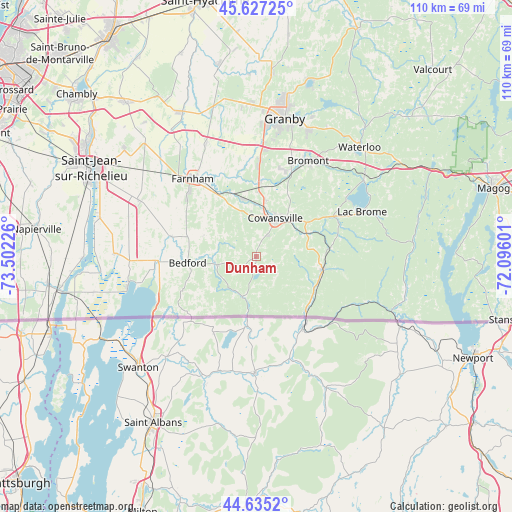
Dunham GPS coordinates[2]
45° 8' 0.168" North, 72° 47' 56.868" West
| Map corner | latitude | longitude |
|---|---|---|
| Upper-left | 45.62725°, | -73.50226° |
| Center: | 45.13338°, | -72.79913° |
| Lower-right: | 44.6352°, | -72.09601° |
| Map W x H: | 110.3×110.3 km | = 68.5×68.5mi |
| max Lat: | 73.03752° ⇑83.1% North |
| Dunham: | 45.13338° |
| min Lat: | ⇓16.9% South 42.05009° |
| min Long | Dunham | max Long |
| -139.43328° | -72.79913° | -52.70931° |
| W 73.2%⇐ | ⇒26.8% E |
Elevation
Elevation of Dunham is 154 m = 505 ft, and this is 100.4 m = 329 ft below average elevation for this country.
| Max E: |
1518 m = 4980 ft | 53.1% |
| Avg. | 254.4 m = 835 ft | |
| Dunham | 154 m = 505 ft | |
Min E: |
-2 m = -7 ft | 46.9% |
See also: Canada elevation on elevation.city.
Geographical zone
Dunham is located in North temperate zone (between Tropic of Cancer and the Arctic Circle). Distance of this North polar circle is 2382.8 km =1480.6 mi to North.| Distance of | km | miles | from Dunham |
|---|---|---|---|
| North Pole | 4988.7 | 3099.8 | to North |
| Arctic Circle | 2382.8 | 1480.6 | to North |
| Tropic Cancer | 2412.4 | 1499 | to South |
| Equator | 5018.4 | 3118.3 | to South |


Nearby cities:
15 places around Dunham: (largest is in red/bold)
• Ange-Gardien
26.3 km =16.3 mi,  336°
336°
• Bedford
14.5 km =9 mi,  262°
262°
• Bromont
23.5 km =14.6 mi,  29°
29°
• Cowansville
8.4 km =5.2 mi, 27°
• Farnham
22 km =13.7 mi,  319°
319°
• Granby
30.1 km =18.7 mi,  9°
9°
• Lac-Brome
24.1 km =15 mi,  67°
67°
• Mont-Saint-Grégoire
36.3 km =22.6 mi,  307°
307°
• Parc-Boutin
40.3 km =25 mi,  295°
295°
• Rougemont
38.7 km =24 mi,  329°
329°
• Saint-Césaire
35.2 km =21.9 mi, 333°
• Sainte-Croix
0.1 km =0.1 mi,  284°
284°
• Sutton
14.9 km =9.3 mi,  104°
104°
• Venise-en-Québec
26.7 km =16.6 mi, 258°
• Waterloo
32.7 km =20.3 mi,  42°
42°
Sources, notices
• [Note1] Compared only with cities in Canada existing in our database
• [Src1] Map data: © OpenStreetMap contributors (CC-BY-SA)
• [Src2] Other city data from geonames.org with taken over terms of usage.
• [Src3] Geographical zone / Annual Mean Temperature by Robert A. Rohde @ Wikipedia
