Sutton geodata
Sutton (Quebec) is a populated place; located in Canada in America/Toronto (GMT-4) time zone. With population of 3,805 people, there are 549 cities with bigger population in this country. Compared to other cities in Canada, 83.3% of cities are located further ↑North; 74% of cities are located further ←West and 50.8% of cities have lower elevation than Sutton. Note1


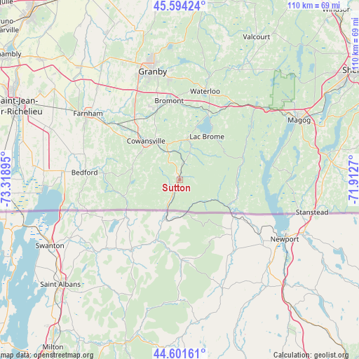
Sutton GPS coordinates[2]
45° 6' 0.288" North, 72° 36' 56.952" West
| Map corner | latitude | longitude |
|---|---|---|
| Upper-left | 45.59424°, | -73.31895° |
| Center: | 45.10008°, | -72.61582° |
| Lower-right: | 44.60161°, | -71.9127° |
| Map W x H: | 110.4×110.4 km | = 68.6×68.6mi |
| max Lat: | 73.03752° ⇑83.3% North |
| Sutton: | 45.10008° |
| min Lat: | ⇓16.7% South 42.05009° |
| min Long | Sutton | max Long |
| -139.43328° | -72.61582° | -52.70931° |
| W 74%⇐ | ⇒26% E |
Elevation
Elevation of Sutton is 176 m = 577 ft, and this is 78.4 m = 257 ft below average elevation for this country.
| Max E: |
1518 m = 4980 ft | 49.2% |
| Avg. | 254.4 m = 835 ft | |
| Sutton | 176 m = 577 ft | |
Min E: |
-2 m = -7 ft | 50.8% |
See also: Canada elevation on elevation.city.
Geographical zone
Sutton is located in North temperate zone (between Tropic of Cancer and the Arctic Circle). Distance of this North polar circle is 2386.5 km =1482.9 mi to North.| Distance of | km | miles | from Sutton |
|---|---|---|---|
| North Pole | 4992.4 | 3102.1 | to North |
| Arctic Circle | 2386.5 | 1482.9 | to North |
| Tropic Cancer | 2408.7 | 1496.7 | to South |
| Equator | 5014.7 | 3116 | to South |


Nearby cities:
15 places around Sutton: (largest is in red/bold)
• Ange-Gardien
37.2 km =23.1 mi,  318°
318°
• Bedford
28.8 km =17.9 mi,  273°
273°
• Bromont
24.2 km =15 mi,  353°
353°
• Cowansville
15.3 km =9.5 mi, 316°
• Dunham
14.9 km =9.3 mi,  284°
284°
• Farnham
35.2 km =21.9 mi,  305°
305°
• Granby
34.6 km =21.5 mi,  344°
344°
• Lac-Brome
15.2 km =9.4 mi,  31°
31°
• Magog
41 km =25.5 mi,  63°
63°
• Rock Island
42.1 km =26.2 mi,  104°
104°
• Rougemont
50.2 km =31.2 mi, 317°
• Saint-Césaire
46.3 km =28.8 mi, 319°
• Sainte-Croix
15 km =9.3 mi, 284°
• Venise-en-Québec
40.6 km =25.2 mi, 267°
• Waterloo
28.9 km =18 mi,  15°
15°
Sources, notices
• [Note1] Compared only with cities in Canada existing in our database
• [Src1] Map data: © OpenStreetMap contributors (CC-BY-SA)
• [Src2] Other city data from geonames.org with taken over terms of usage.
• [Src3] Geographical zone / Annual Mean Temperature by Robert A. Rohde @ Wikipedia
