Cobourg geodata
Cobourg (Ontario) is a populated place; located in Canada in America/Toronto (GMT-4) time zone. With population of 18,099 people, there are 205 cities with bigger population in this country. Compared to other cities in Canada, 92.1% of cities are located further ↑North; 51.6% of cities are located further ←West and 63.9% of cities have higher elevation than Cobourg. Note1


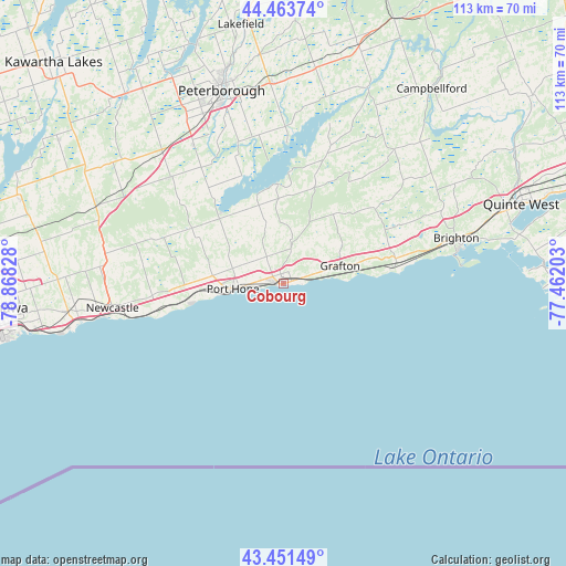
Cobourg GPS coordinates[2]
43° 57' 35.172" North, 78° 9' 54.54" West
| Map corner | latitude | longitude |
|---|---|---|
| Upper-left | 44.46374°, | -78.86828° |
| Center: | 43.95977°, | -78.16515° |
| Lower-right: | 43.45149°, | -77.46203° |
| Map W x H: | 112.6×112.6 km | = 70×70mi |
| max Lat: | 73.03752° ⇑92.1% North |
| Cobourg: | 43.95977° |
| min Lat: | ⇓7.9% South 42.05009° |
| min Long | Cobourg | max Long |
| -139.43328° | -78.16515° | -52.70931° |
| W 51.6%⇐ | ⇒48.4% E |
Elevation
Elevation of Cobourg is 82 m = 269 ft, and this is 172.4 m = 566 ft below average elevation for this country.
| Max E: |
1518 m = 4980 ft | 63.9% |
| Avg. | 254.4 m = 835 ft | |
| Cobourg | 82 m = 269 ft | |
Min E: |
-2 m = -7 ft | 36.1% |
See also: Canada elevation on elevation.city.
Geographical zone
Cobourg is located in North temperate zone (between Tropic of Cancer and the Arctic Circle). Distance of this Northern Tropic circle is 2281.9 km =1417.9 mi to South.| Distance of | km | miles | from Cobourg |
|---|---|---|---|
| North Pole | 5119.2 | 3180.9 | to North |
| Arctic Circle | 2513.3 | 1561.7 | to North |
| Tropic Cancer | 2281.9 | 1417.9 | to South |
| Equator | 4887.9 | 3037.2 | to South |


Nearby cities:
15 places around Cobourg: (largest is in red/bold)
• Ajax
70.6 km =43.9 mi,  260°
260°
• Belleville
66.6 km =41.4 mi,  69°
69°
• Blackstock
54.3 km =33.7 mi,  286°
286°
• Caesarea
57.4 km =35.7 mi, 291°
• Greenbank
71.2 km =44.2 mi, 287°
• Lakefield
53.3 km =33.1 mi,  351°
351°
• Lindsay
62.7 km =39 mi,  313°
313°
• Millbrook
31.1 km =19.3 mi, 312°
• Norwood
49.3 km =30.6 mi,  17°
17°
• Omemee
49.1 km =30.5 mi,  320°
320°
• Oshawa
55.2 km =34.3 mi, 263°
• Peterborough
39.7 km =24.7 mi,  342°
342°
• Port Hope
19.8 km =12.3 mi, 288°
• Quinte West
53.9 km =33.5 mi,  62°
62°
• Stirling
62 km =38.5 mi,  52°
52°
Sources, notices
• [Note1] Compared only with cities in Canada existing in our database
• [Src1] Map data: © OpenStreetMap contributors (CC-BY-SA)
• [Src2] Other city data from geonames.org with taken over terms of usage.
• [Src3] Geographical zone / Annual Mean Temperature by Robert A. Rohde @ Wikipedia
