Norfolk County geodata
Norfolk County (Ontario) is a populated place; located in Canada in America/Toronto (GMT-4) time zone. With population of 60,847 people, there are 88 cities with bigger population in this country. Compared to other cities in Canada, 98.8% of cities are located further ↑North; 56.7% of cities are located further →East and 60.4% of cities have lower elevation than Norfolk County. Note1


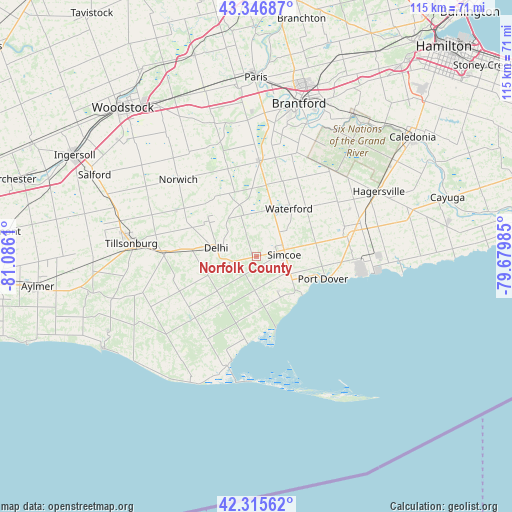
Norfolk County GPS coordinates[2]
42° 50' 0.24" North, 80° 22' 58.692" West
| Map corner | latitude | longitude |
|---|---|---|
| Upper-left | 43.34687°, | -81.0861° |
| Center: | 42.8334°, | -80.38297° |
| Lower-right: | 42.31562°, | -79.67985° |
| Map W x H: | 114.7×114.7 km | = 71.3×71.3mi |
| max Lat: | 73.03752° ⇑98.8% North |
| Norfolk County: | 42.8334° |
| min Lat: | ⇓1.2% South 42.05009° |
| min Long | Norfolk County | max Long |
| -139.43328° | -80.38297° | -52.70931° |
| W 43.3%⇐ | ⇒56.7% E |
Elevation
Elevation of Norfolk County is 235 m = 771 ft, and this is 19.4 m = 64 ft below average elevation for this country.
| Max E: |
1518 m = 4980 ft | 39.6% |
| Avg. | 254.4 m = 835 ft | |
| Norfolk County | 235 m = 771 ft | |
Min E: |
-2 m = -7 ft | 60.4% |
See also: Norfolk County elevation on elevation.city.
Geographical zone
Norfolk County is located in North temperate zone (between Tropic of Cancer and the Arctic Circle). Distance of this Northern Tropic circle is 2156.7 km =1340.1 mi to South.| Distance of | km | miles | from Norfolk County |
|---|---|---|---|
| North Pole | 5244.4 | 3258.7 | to North |
| Arctic Circle | 2638.5 | 1639.5 | to North |
| Tropic Cancer | 2156.7 | 1340.1 | to South |
| Equator | 4762.6 | 2959.3 | to South |


Nearby cities:
15 places around Norfolk County: (largest is in red/bold)
• Ancaster
53.5 km =33.2 mi,  36°
36°
• Aylmer
49.5 km =30.8 mi,  261°
261°
• Binbrook
56.5 km =35.1 mi,  55°
55°
• Brant
33.5 km =20.8 mi,  4°
4°
• Brantford
34.7 km =21.6 mi,  15°
15°
• Burford
30.2 km =18.8 mi,  352°
352°
• Ingersoll
46.4 km =28.8 mi,  298°
298°
• Jarvis
23.8 km =14.8 mi,  76°
76°
• Paris
40.8 km =25.4 mi,  359°
359°
• Plattsville
55.2 km =34.3 mi,  339°
339°
• Port Rowan
25 km =15.5 mi,  195°
195°
• Simcoe
6.8 km =4.2 mi,  90°
90°
• St. George
47 km =29.2 mi,  13°
13°
• Waterford
13.8 km =8.6 mi, 36°
• Woodstock
44.7 km =27.8 mi,  318°
318°
Sources, notices
• [Note1] Compared only with cities in Canada existing in our database
• [Src1] Map data: © OpenStreetMap contributors (CC-BY-SA)
• [Src2] Other city data from geonames.org with taken over terms of usage.
• [Src3] Geographical zone / Annual Mean Temperature by Robert A. Rohde @ Wikipedia
