Burford geodata
Burford (Ontario) is a populated place; located in Canada in America/Toronto (GMT-4) time zone. With population of 1,615 people, there are 835 cities with bigger population in this country. Compared to other cities in Canada, 97.1% of cities are located further ↑North; 56.9% of cities are located further →East and 65.4% of cities have lower elevation than Burford. Note1


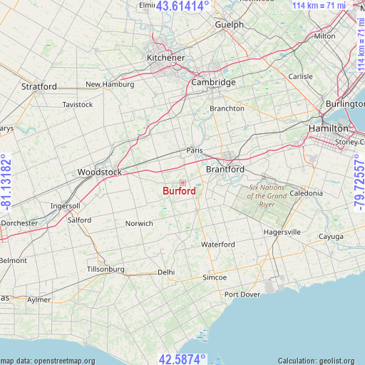
Burford GPS coordinates[2]
43° 6' 10.512" North, 80° 25' 43.284" West
| Map corner | latitude | longitude |
|---|---|---|
| Upper-left | 43.61414°, | -81.13182° |
| Center: | 43.10292°, | -80.42869° |
| Lower-right: | 42.5874°, | -79.72557° |
| Map W x H: | 114.2×114.2 km | = 71×71mi |
| max Lat: | 73.03752° ⇑97.1% North |
| Burford: | 43.10292° |
| min Lat: | ⇓2.9% South 42.05009° |
| min Long | Burford | max Long |
| -139.43328° | -80.42869° | -52.70931° |
| W 43.1%⇐ | ⇒56.9% E |
Elevation
Elevation of Burford is 258 m = 846 ft, and this is 3.6 m = 12 ft above average elevation for this country.
| Max E: |
1518 m = 4980 ft | 34.6% |
| Burford | 258 m 846 ft | |
| Avg. | 254.4 m = 835 ft | |
Min E: |
-2 m = -7 ft | 65.4% |
See also: Canada elevation on elevation.city.
Geographical zone
Burford is located in North temperate zone (between Tropic of Cancer and the Arctic Circle). Distance of this Northern Tropic circle is 2186.7 km =1358.8 mi to South.| Distance of | km | miles | from Burford |
|---|---|---|---|
| North Pole | 5214.5 | 3240.1 | to North |
| Arctic Circle | 2608.6 | 1620.9 | to North |
| Tropic Cancer | 2186.7 | 1358.8 | to South |
| Equator | 4792.6 | 2978 | to South |


Nearby cities:
15 places around Burford: (largest is in red/bold)
• Ancaster
38 km =23.6 mi,  70°
70°
• Brant
7.3 km =4.5 mi,  62°
62°
• Brantford
13.6 km =8.5 mi,  75°
75°
• Cambridge
30.1 km =18.7 mi,  18°
18°
• Ingersoll
37.7 km =23.4 mi,  258°
258°
• Jarvis
36.2 km =22.5 mi,  132°
132°
• Kitchener
36.5 km =22.7 mi,  349°
349°
• New Hamburg
38.1 km =23.7 mi,  324°
324°
• Norfolk County
30.2 km =18.8 mi,  172°
172°
• Paris
11.4 km =7.1 mi, 18°
• Plattsville
26.7 km =16.6 mi,  325°
325°
• Simcoe
31.8 km =19.8 mi,  160°
160°
• St. George
21.4 km =13.3 mi,  42°
42°
• Waterford
22.3 km =13.9 mi,  147°
147°
• Woodstock
26.3 km =16.3 mi,  277°
277°
Sources, notices
• [Note1] Compared only with cities in Canada existing in our database
• [Src1] Map data: © OpenStreetMap contributors (CC-BY-SA)
• [Src2] Other city data from geonames.org with taken over terms of usage.
• [Src3] Geographical zone / Annual Mean Temperature by Robert A. Rohde @ Wikipedia
