Woodstock geodata
Woodstock (Ontario) is a seat of a second-order administrative division; located in Canada in America/Toronto (GMT-4) time zone. With population of 40,404 people, there are 120 cities with bigger population in this country. Compared to other cities in Canada, 96.9% of cities are located further ↑North; 58% of cities are located further →East and 69.3% of cities have lower elevation than Woodstock. Note1


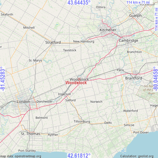
Woodstock GPS coordinates[2]
43° 8' 0.204" North, 80° 44' 58.92" West
| Map corner | latitude | longitude |
|---|---|---|
| Upper-left | 43.64435°, | -81.45283° |
| Center: | 43.13339°, | -80.7497° |
| Lower-right: | 42.61812°, | -80.04658° |
| Map W x H: | 114.1×114.1 km | = 70.9×70.9mi |
| max Lat: | 73.03752° ⇑96.9% North |
| Woodstock: | 43.13339° |
| min Lat: | ⇓3.1% South 42.05009° |
| min Long | Woodstock | max Long |
| -139.43328° | -80.7497° | -52.70931° |
| W 42%⇐ | ⇒58% E |
Elevation
Elevation of Woodstock is 299 m = 981 ft, and this is 44.6 m = 146 ft above average elevation for this country.
| Max E: |
1518 m = 4980 ft | 30.7% |
| Woodstock | 299 m 981 ft | |
| Avg. | 254.4 m = 835 ft | |
Min E: |
-2 m = -7 ft | 69.3% |
See also: Woodstock elevation on elevation.city.
Geographical zone
Woodstock is located in North temperate zone (between Tropic of Cancer and the Arctic Circle). Distance of this Northern Tropic circle is 2190.1 km =1360.9 mi to South.| Distance of | km | miles | from Woodstock |
|---|---|---|---|
| North Pole | 5211.1 | 3238 | to North |
| Arctic Circle | 2605.2 | 1618.8 | to North |
| Tropic Cancer | 2190.1 | 1360.9 | to South |
| Equator | 4796 | 2980.1 | to South |


Nearby cities:
15 places around Woodstock: (largest is in red/bold)
• Belmont
38.8 km =24.1 mi,  224°
224°
• Brant
32.5 km =20.2 mi,  89°
89°
• Brantford
39.2 km =24.4 mi, 89°
• Burford
26.3 km =16.3 mi,  97°
97°
• Dorchester
30.7 km =19.1 mi,  237°
237°
• Ingersoll
15.5 km =9.6 mi, 224°
• Kitchener
37.8 km =23.5 mi,  30°
30°
• New Hamburg
28.1 km =17.5 mi,  8°
8°
• Paris
30.6 km =19 mi,  76°
76°
• Plattsville
21.5 km =13.4 mi, 30°
• St. George
42.3 km =26.3 mi,  72°
72°
• Stratford
30.6 km =19 mi,  328°
328°
• Tavistock
21.5 km =13.4 mi,  341°
341°
• Waterloo
41.6 km =25.8 mi, 26°
• Wellesley
38.2 km =23.7 mi,  358°
358°
Sources, notices
• [Note1] Compared only with cities in Canada existing in our database
• [Src1] Map data: © OpenStreetMap contributors (CC-BY-SA)
• [Src2] Other city data from geonames.org with taken over terms of usage.
• [Src3] Geographical zone / Annual Mean Temperature by Robert A. Rohde @ Wikipedia
