Ingersoll geodata
Ingersoll (Ontario) is a populated place; located in Canada in America/Toronto (GMT-4) time zone. With population of 11,874 people, there are 280 cities with bigger population in this country. Compared to other cities in Canada, 97.4% of cities are located further ↑North; 58.3% of cities are located further →East and 68.9% of cities have lower elevation than Ingersoll. Note1


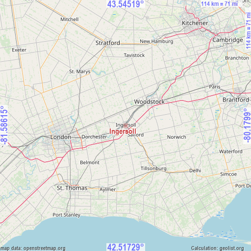
Ingersoll GPS coordinates[2]
43° 2' 0.204" North, 80° 52' 58.872" West
| Map corner | latitude | longitude |
|---|---|---|
| Upper-left | 43.54519°, | -81.58615° |
| Center: | 43.03339°, | -80.88302° |
| Lower-right: | 42.51729°, | -80.1799° |
| Map W x H: | 114.3×114.3 km | = 71×71mi |
| max Lat: | 73.03752° ⇑97.4% North |
| Ingersoll: | 43.03339° |
| min Lat: | ⇓2.6% South 42.05009° |
| min Long | Ingersoll | max Long |
| -139.43328° | -80.88302° | -52.70931° |
| W 41.7%⇐ | ⇒58.3% E |
Elevation
Elevation of Ingersoll is 293 m = 961 ft, and this is 38.6 m = 127 ft above average elevation for this country.
| Max E: |
1518 m = 4980 ft | 31.1% |
| Ingersoll | 293 m 961 ft | |
| Avg. | 254.4 m = 835 ft | |
Min E: |
-2 m = -7 ft | 68.9% |
See also: Canada elevation on elevation.city.
Geographical zone
Ingersoll is located in North temperate zone (between Tropic of Cancer and the Arctic Circle). Distance of this Northern Tropic circle is 2178.9 km =1353.9 mi to South.| Distance of | km | miles | from Ingersoll |
|---|---|---|---|
| North Pole | 5222.2 | 3244.9 | to North |
| Arctic Circle | 2616.3 | 1625.7 | to North |
| Tropic Cancer | 2178.9 | 1353.9 | to South |
| Equator | 4784.9 | 2973.2 | to South |


Nearby cities:
15 places around Ingersoll: (largest is in red/bold)
• Aylmer
30.7 km =19.1 mi,  195°
195°
• Belmont
23.3 km =14.5 mi,  224°
224°
• Brant
44.7 km =27.8 mi,  75°
75°
• Burford
37.7 km =23.4 mi, 78°
• Delaware
45.3 km =28.1 mi,  253°
253°
• Dorchester
15.9 km =9.9 mi, 249°
• London
29 km =18 mi,  258°
258°
• Lucan
45.1 km =28 mi,  291°
291°
• New Hamburg
41.7 km =25.9 mi,  20°
20°
• Paris
44.6 km =27.7 mi,  65°
65°
• Plattsville
36.7 km =22.8 mi,  36°
36°
• St. Thomas
37.7 km =23.4 mi, 219°
• Stratford
37.5 km =23.3 mi,  351°
351°
• Tavistock
31.8 km =19.8 mi,  7°
7°
• Woodstock
15.5 km =9.6 mi, 44°
Sources, notices
• [Note1] Compared only with cities in Canada existing in our database
• [Src1] Map data: © OpenStreetMap contributors (CC-BY-SA)
• [Src2] Other city data from geonames.org with taken over terms of usage.
• [Src3] Geographical zone / Annual Mean Temperature by Robert A. Rohde @ Wikipedia
