L'Assomption geodata
L'Assomption (Quebec) is a populated place; located in Canada in America/Toronto (GMT-4) time zone. With population of 15,906 people, there are 230 cities with bigger population in this country. Compared to other cities in Canada, 67.4% of cities are located further ↑North; 69.1% of cities are located further ←West and 91.2% of cities have higher elevation than L'Assomption. Note1


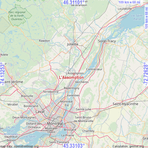
L'Assomption GPS coordinates[2]
45° 49' 23.448" North, 73° 25' 45.84" West
| Map corner | latitude | longitude |
|---|---|---|
| Upper-left | 46.31101°, | -74.13253° |
| Center: | 45.82318°, | -73.4294° |
| Lower-right: | 45.33103°, | -72.72628° |
| Map W x H: | 109×109 km | = 67.7×67.7mi |
| max Lat: | 73.03752° ⇑67.4% North |
| L'Assomption: | 45.82318° |
| min Lat: | ⇓32.6% South 42.05009° |
| min Long | L'Assomption | max Long |
| -139.43328° | -73.4294° | -52.70931° |
| W 69.1%⇐ | ⇒30.9% E |
Elevation
Elevation of L'Assomption is 13 m = 43 ft, and this is 241.4 m = 792 ft below average elevation for this country.
| Max E: |
1518 m = 4980 ft | 91.2% |
| Avg. | 254.4 m = 835 ft | |
| L'Assomption | 13 m = 43 ft | |
Min E: |
-2 m = -7 ft | 8.8% |
See also: Canada elevation on elevation.city.
Geographical zone
L'Assomption is located in North temperate zone (between Tropic of Cancer and the Arctic Circle). Distance of this North polar circle is 2306.1 km =1432.9 mi to North.| Distance of | km | miles | from L'Assomption |
|---|---|---|---|
| North Pole | 4912 | 3052.2 | to North |
| Arctic Circle | 2306.1 | 1432.9 | to North |
| Tropic Cancer | 2489.1 | 1546.7 | to South |
| Equator | 5095.1 | 3165.9 | to South |


Nearby cities:
15 places around L'Assomption: (largest is in red/bold)
• Charlemagne
12.5 km =7.8 mi,  199°
199°
• Contrecoeur
15.5 km =9.6 mi,  78°
78°
• Crabtree
16.2 km =10.1 mi,  349°
349°
• Joliette
21.5 km =13.4 mi,  1°
1°
• L'Épiphanie
5.1 km =3.2 mi,  306°
306°
• Lavaltrie
13.2 km =8.2 mi,  59°
59°
• Mascouche
15.5 km =9.6 mi,  238°
238°
• Repentigny
9.1 km =5.7 mi,  190°
190°
• Saint-Amable
21.7 km =13.5 mi,  152°
152°
• Saint-Charles
16.5 km =10.3 mi,  215°
215°
• Saint-Jacques
17.7 km =11 mi,  321°
321°
• Saint-Joseph
22.1 km =13.7 mi,  47°
47°
• Terrebonne
21.8 km =13.5 mi,  230°
230°
• Varennes
15.5 km =9.6 mi,  180°
180°
• Verchères
7.6 km =4.7 mi,  125°
125°
Sources, notices
• [Note1] Compared only with cities in Canada existing in our database
• [Src1] Map data: © OpenStreetMap contributors (CC-BY-SA)
• [Src2] Other city data from geonames.org with taken over terms of usage.
• [Src3] Geographical zone / Annual Mean Temperature by Robert A. Rohde @ Wikipedia
