Rawdon geodata
Rawdon (Quebec) is a populated place; located in Canada in America/Toronto (GMT-4) time zone. With population of 5,188 people, there are 467 cities with bigger population in this country. Compared to other cities in Canada, 62.3% of cities are located further ↑North; 65.7% of cities are located further ←West and 50.8% of cities have lower elevation than Rawdon. Note1


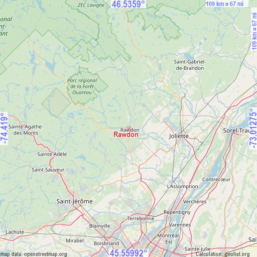
Rawdon GPS coordinates[2]
46° 3' 0.252" North, 73° 42' 57.132" West
| Map corner | latitude | longitude |
|---|---|---|
| Upper-left | 46.5359°, | -74.419° |
| Center: | 46.05007°, | -73.71587° |
| Lower-right: | 45.55992°, | -73.01275° |
| Map W x H: | 108.5×108.5 km | = 67.4×67.4mi |
| max Lat: | 73.03752° ⇑62.3% North |
| Rawdon: | 46.05007° |
| min Lat: | ⇓37.7% South 42.05009° |
| min Long | Rawdon | max Long |
| -139.43328° | -73.71587° | -52.70931° |
| W 65.7%⇐ | ⇒34.3% E |
Elevation
Elevation of Rawdon is 176 m = 577 ft, and this is 78.4 m = 257 ft below average elevation for this country.
| Max E: |
1518 m = 4980 ft | 49.2% |
| Avg. | 254.4 m = 835 ft | |
| Rawdon | 176 m = 577 ft | |
Min E: |
-2 m = -7 ft | 50.8% |
See also: Canada elevation on elevation.city.
Geographical zone
Rawdon is located in North temperate zone (between Tropic of Cancer and the Arctic Circle). Distance of this North polar circle is 2280.9 km =1417.3 mi to North.| Distance of | km | miles | from Rawdon |
|---|---|---|---|
| North Pole | 4886.8 | 3036.5 | to North |
| Arctic Circle | 2280.9 | 1417.3 | to North |
| Tropic Cancer | 2514.4 | 1562.4 | to South |
| Equator | 5120.3 | 3181.6 | to South |


Nearby cities:
15 places around Rawdon: (largest is in red/bold)
• Chertsey
13.7 km =8.5 mi,  279°
279°
• Crabtree
21.4 km =13.3 mi,  115°
115°
• Joliette
22.9 km =14.2 mi,  99°
99°
• Lac-Connelly
26.1 km =16.2 mi,  229°
229°
• Lac-Lapierre
17.4 km =10.8 mi,  194°
194°
• Notre-Dame-des-Prairies
21.9 km =13.6 mi,  90°
90°
• Saint-Ambroise
12.7 km =7.9 mi,  76°
76°
• Saint-Félix-de-Valois
26.1 km =16.2 mi,  59°
59°
• Saint-Hippolyte
26.6 km =16.5 mi,  240°
240°
• Saint-Jacques
15.9 km =9.9 mi,  135°
135°
• Saint-Lin-Laurentides
22.6 km =14 mi, 189°
• Saint-Thomas
28.5 km =17.7 mi, 97°
• Sainte-Béatrix
18.4 km =11.4 mi,  24°
24°
• Sainte-Julienne
9.3 km =5.8 mi,  180°
180°
• Sainte-Élisabeth
28.5 km =17.7 mi, 79°
Sources, notices
• [Note1] Compared only with cities in Canada existing in our database
• [Src1] Map data: © OpenStreetMap contributors (CC-BY-SA)
• [Src2] Other city data from geonames.org with taken over terms of usage.
• [Src3] Geographical zone / Annual Mean Temperature by Robert A. Rohde @ Wikipedia
