Boisbriand geodata
Boisbriand (Quebec) is a populated place; located in Canada in America/Toronto (GMT-4) time zone. With population of 26,483 people, there are 153 cities with bigger population in this country. Compared to other cities in Canada, 71.5% of cities are located further ↑North; 64.3% of cities are located further ←West and 81.3% of cities have higher elevation than Boisbriand. Note1


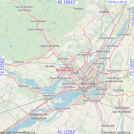
Boisbriand GPS coordinates[2]
45° 37' 0.408" North, 73° 49' 56.964" West
| Map corner | latitude | longitude |
|---|---|---|
| Upper-left | 46.10643°, | -74.53562° |
| Center: | 45.61678°, | -73.83249° |
| Lower-right: | 45.12282°, | -73.12937° |
| Map W x H: | 109.4×109.4 km | = 68×68mi |
| max Lat: | 73.03752° ⇑71.5% North |
| Boisbriand: | 45.61678° |
| min Lat: | ⇓28.5% South 42.05009° |
| min Long | Boisbriand | max Long |
| -139.43328° | -73.83249° | -52.70931° |
| W 64.3%⇐ | ⇒35.7% E |
Elevation
Elevation of Boisbriand is 30 m = 98 ft, and this is 224.4 m = 736 ft below average elevation for this country.
| Max E: |
1518 m = 4980 ft | 81.3% |
| Avg. | 254.4 m = 835 ft | |
| Boisbriand | 30 m = 98 ft | |
Min E: |
-2 m = -7 ft | 18.7% |
See also: Canada elevation on elevation.city.
Geographical zone
Boisbriand is located in North temperate zone (between Tropic of Cancer and the Arctic Circle). Distance of this North polar circle is 2329.1 km =1447.2 mi to North.| Distance of | km | miles | from Boisbriand |
|---|---|---|---|
| North Pole | 4935 | 3066.5 | to North |
| Arctic Circle | 2329.1 | 1447.2 | to North |
| Tropic Cancer | 2466.2 | 1532.4 | to South |
| Equator | 5072.1 | 3151.7 | to South |


Nearby cities:
15 places around Boisbriand: (largest is in red/bold)
• Blainville
6.8 km =4.2 mi,  325°
325°
• Bois-des-Filion
8.5 km =5.3 mi,  49°
49°
• Deux-Montagnes
10.6 km =6.6 mi,  210°
210°
• Dollard-Des Ormeaux
13.6 km =8.5 mi,  177°
177°
• Laval
12.1 km =7.5 mi,  115°
115°
• Lorraine
8.4 km =5.2 mi,  27°
27°
• Pointe-Calumet
16.6 km =10.3 mi,  218°
218°
• Rosemère
3.2 km =2 mi, 54°
• Saint-Elzéar
8.3 km =5.2 mi,  100°
100°
• Saint-Eustache
8.1 km =5 mi, 224°
• Saint-Joseph-du-Lac
15.9 km =9.9 mi,  234°
234°
• Sainte-Anne-des-Plaines
16.5 km =10.3 mi,  5°
5°
• Sainte-Marthe-sur-le-Lac
12.1 km =7.5 mi, 220°
• Sainte-Thérèse
2.5 km =1.6 mi, 8°
• Terrebonne
17.1 km =10.6 mi,  57°
57°
Sources, notices
• [Note1] Compared only with cities in Canada existing in our database
• [Src1] Map data: © OpenStreetMap contributors (CC-BY-SA)
• [Src2] Other city data from geonames.org with taken over terms of usage.
• [Src3] Geographical zone / Annual Mean Temperature by Robert A. Rohde @ Wikipedia
