Rosemère geodata
Rosemère (Quebec) is a populated place; located in Canada in America/Toronto (GMT-4) time zone. With population of 14,173 people, there are 251 cities with bigger population in this country. Compared to other cities in Canada, 71% of cities are located further ↑North; 64.7% of cities are located further ←West and 81.9% of cities have higher elevation than Rosemère. Note1


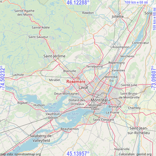
Rosemère GPS coordinates[2]
45° 38' 0.168" North, 73° 47' 57.084" West
| Map corner | latitude | longitude |
|---|---|---|
| Upper-left | 46.12288°, | -74.50232° |
| Center: | 45.63338°, | -73.79919° |
| Lower-right: | 45.13957°, | -73.09607° |
| Map W x H: | 109.3×109.3 km | = 67.9×67.9mi |
| max Lat: | 73.03752° ⇑71% North |
| Rosemère: | 45.63338° |
| min Lat: | ⇓29% South 42.05009° |
| min Long | Rosemère | max Long |
| -139.43328° | -73.79919° | -52.70931° |
| W 64.7%⇐ | ⇒35.3% E |
Elevation
Elevation of Rosemère is 29 m = 95 ft, and this is 225.4 m = 740 ft below average elevation for this country.
| Max E: |
1518 m = 4980 ft | 81.9% |
| Avg. | 254.4 m = 835 ft | |
| Rosemère | 29 m = 95 ft | |
Min E: |
-2 m = -7 ft | 18.1% |
See also: Canada elevation on elevation.city.
Geographical zone
Rosemère is located in North temperate zone (between Tropic of Cancer and the Arctic Circle). Distance of this North polar circle is 2327.2 km =1446.1 mi to North.| Distance of | km | miles | from Rosemère |
|---|---|---|---|
| North Pole | 4933.1 | 3065.3 | to North |
| Arctic Circle | 2327.2 | 1446.1 | to North |
| Tropic Cancer | 2468 | 1533.5 | to South |
| Equator | 5074 | 3152.8 | to South |


Nearby cities:
15 places around Rosemère: (largest is in red/bold)
• Blainville
7.5 km =4.7 mi,  299°
299°
• Bois-des-Filion
5.4 km =3.4 mi,  46°
46°
• Boisbriand
3.2 km =2 mi,  234°
234°
• Deux-Montagnes
13.6 km =8.5 mi,  215°
215°
• Dollard-Des Ormeaux
15.6 km =9.7 mi,  187°
187°
• Laval
10.9 km =6.8 mi,  130°
130°
• Lorraine
5.7 km =3.5 mi,  13°
13°
• Saint-Elzéar
6.5 km =4 mi,  120°
120°
• Saint-Eustache
11.2 km =7 mi, 227°
• Saint-Léonard
16.7 km =10.4 mi,  107°
107°
• Saint-Michel
15.6 km =9.7 mi, 117°
• Sainte-Anne-des-Plaines
14.6 km =9.1 mi,  356°
356°
• Sainte-Marthe-sur-le-Lac
15.2 km =9.4 mi, 223°
• Sainte-Thérèse
2.3 km =1.4 mi,  286°
286°
• Terrebonne
13.9 km =8.6 mi,  57°
57°
Sources, notices
• [Note1] Compared only with cities in Canada existing in our database
• [Src1] Map data: © OpenStreetMap contributors (CC-BY-SA)
• [Src2] Other city data from geonames.org with taken over terms of usage.
• [Src3] Geographical zone / Annual Mean Temperature by Robert A. Rohde @ Wikipedia
