Ormstown geodata
Ormstown (Quebec) is a populated place; located in Canada in America/Toronto (GMT-4) time zone. With population of 1,730 people, there are 805 cities with bigger population in this country. Compared to other cities in Canada, 83.1% of cities are located further ↑North; 62.4% of cities are located further ←West and 77.1% of cities have higher elevation than Ormstown. Note1


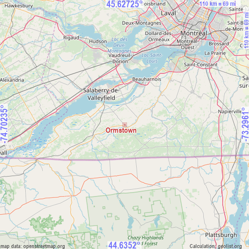
Ormstown GPS coordinates[2]
45° 8' 0.168" North, 73° 59' 57.192" West
| Map corner | latitude | longitude |
|---|---|---|
| Upper-left | 45.62725°, | -74.70235° |
| Center: | 45.13338°, | -73.99922° |
| Lower-right: | 44.6352°, | -73.2961° |
| Map W x H: | 110.3×110.3 km | = 68.5×68.5mi |
| max Lat: | 73.03752° ⇑83.1% North |
| Ormstown: | 45.13338° |
| min Lat: | ⇓16.9% South 42.05009° |
| min Long | Ormstown | max Long |
| -139.43328° | -73.99922° | -52.70931° |
| W 62.4%⇐ | ⇒37.6% E |
Elevation
Elevation of Ormstown is 38 m = 125 ft, and this is 216.4 m = 710 ft below average elevation for this country.
| Max E: |
1518 m = 4980 ft | 77.1% |
| Avg. | 254.4 m = 835 ft | |
| Ormstown | 38 m = 125 ft | |
Min E: |
-2 m = -7 ft | 22.9% |
See also: Canada elevation on elevation.city.
Geographical zone
Ormstown is located in North temperate zone (between Tropic of Cancer and the Arctic Circle). Distance of this North polar circle is 2382.8 km =1480.6 mi to North.| Distance of | km | miles | from Ormstown |
|---|---|---|---|
| North Pole | 4988.7 | 3099.8 | to North |
| Arctic Circle | 2382.8 | 1480.6 | to North |
| Tropic Cancer | 2412.4 | 1499 | to South |
| Equator | 5018.4 | 3118.3 | to South |


Nearby cities:
15 places around Ormstown: (largest is in red/bold)
• Beauharnois
22.3 km =13.9 mi,  26°
26°
• Coteau-du-Lac
23.4 km =14.5 mi,  322°
322°
• Franklin
12.9 km =8 mi,  149°
149°
• Huntingdon
14.2 km =8.8 mi,  246°
246°
• L'Île-Perrot
28.1 km =17.5 mi,  8°
8°
• Les Coteaux
24.7 km =15.3 mi,  312°
312°
• Les Cèdres
18.9 km =11.7 mi,  348°
348°
• Melocheville
21 km =13 mi, 13°
• Mercier
28.3 km =17.6 mi,  43°
43°
• Notre-Dame-de-l'Île-Perrot
26.5 km =16.5 mi, 11°
• Pincourt
27.8 km =17.3 mi,  2°
2°
• Saint-Jean-Baptiste
27.5 km =17.1 mi,  357°
357°
• Saint-Zotique
23.5 km =14.6 mi,  303°
303°
• Sainte-Martine
20.3 km =12.6 mi,  50°
50°
• Salaberry-de-Valleyfield
16.7 km =10.4 mi, 321°
Sources, notices
• [Note1] Compared only with cities in Canada existing in our database
• [Src1] Map data: © OpenStreetMap contributors (CC-BY-SA)
• [Src2] Other city data from geonames.org with taken over terms of usage.
• [Src3] Geographical zone / Annual Mean Temperature by Robert A. Rohde @ Wikipedia
