Saint-Amable geodata
Saint-Amable (Quebec) is a populated place; located in Canada in America/Toronto (GMT-4) time zone. With population of 9,486 people, there are 327 cities with bigger population in this country. Compared to other cities in Canada, 70.7% of cities are located further ↑North; 70.3% of cities are located further ←West and 74.7% of cities have higher elevation than Saint-Amable. Note1


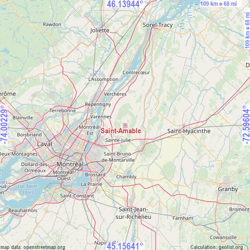
Saint-Amable GPS coordinates[2]
45° 39' 0.288" North, 73° 17' 56.976" West
| Map corner | latitude | longitude |
|---|---|---|
| Upper-left | 46.13944°, | -74.00229° |
| Center: | 45.65008°, | -73.29916° |
| Lower-right: | 45.15641°, | -72.59604° |
| Map W x H: | 109.3×109.3 km | = 67.9×67.9mi |
| max Lat: | 73.03752° ⇑70.7% North |
| Saint-Amable: | 45.65008° |
| min Lat: | ⇓29.3% South 42.05009° |
| min Long | Saint-Amable | max Long |
| -139.43328° | -73.29916° | -52.70931° |
| W 70.3%⇐ | ⇒29.7% E |
Elevation
Elevation of Saint-Amable is 44 m = 144 ft, and this is 210.4 m = 690 ft below average elevation for this country.
| Max E: |
1518 m = 4980 ft | 74.7% |
| Avg. | 254.4 m = 835 ft | |
| Saint-Amable | 44 m = 144 ft | |
Min E: |
-2 m = -7 ft | 25.3% |
See also: Canada elevation on elevation.city.
Geographical zone
Saint-Amable is located in North temperate zone (between Tropic of Cancer and the Arctic Circle). Distance of this North polar circle is 2325.4 km =1444.9 mi to North.| Distance of | km | miles | from Saint-Amable |
|---|---|---|---|
| North Pole | 4931.2 | 3064.1 | to North |
| Arctic Circle | 2325.4 | 1444.9 | to North |
| Tropic Cancer | 2469.9 | 1534.7 | to South |
| Equator | 5075.8 | 3154 | to South |


Nearby cities:
15 places around Saint-Amable: (largest is in red/bold)
• Beloeil
11.6 km =7.2 mi,  141°
141°
• Boucherville
12.5 km =7.8 mi,  238°
238°
• Charlemagne
16.1 km =10 mi,  297°
297°
• Mont-Saint-Hilaire
12.9 km =8 mi, 137°
• Montréal-Est
16.3 km =10.1 mi,  262°
262°
• Otterburn Park
14.5 km =9 mi,  153°
153°
• Repentigny
15.6 km =9.7 mi,  311°
311°
• Saint-Basile-le-Grand
13 km =8.1 mi,  174°
174°
• Saint-Bruno-de-Montarville
13.5 km =8.4 mi,  196°
196°
• Saint-Denis-sur-Richelieu
18.8 km =11.7 mi,  38°
38°
• Saint-Victor
17.4 km =10.8 mi, 255°
• Sainte-Julie
7.9 km =4.9 mi, 199°
• Sainte-Madeleine
16.5 km =10.3 mi,  109°
109°
• Varennes
11 km =6.8 mi,  289°
289°
• Verchères
15.3 km =9.5 mi,  345°
345°
Sources, notices
• [Note1] Compared only with cities in Canada existing in our database
• [Src1] Map data: © OpenStreetMap contributors (CC-BY-SA)
• [Src2] Other city data from geonames.org with taken over terms of usage.
• [Src3] Geographical zone / Annual Mean Temperature by Robert A. Rohde @ Wikipedia
