Charlemagne geodata
Charlemagne (Quebec) is a populated place; located in Canada in America/Toronto (GMT-4) time zone. With population of 5,594 people, there are 449 cities with bigger population in this country. Compared to other cities in Canada, 68.9% of cities are located further ↑North; 68.4% of cities are located further ←West and 96% of cities have higher elevation than Charlemagne. Note1


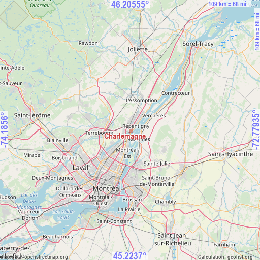
Charlemagne GPS coordinates[2]
45° 43' 0.408" North, 73° 28' 56.892" West
| Map corner | latitude | longitude |
|---|---|---|
| Upper-left | 46.20555°, | -74.1856° |
| Center: | 45.71678°, | -73.48247° |
| Lower-right: | 45.2237°, | -72.77935° |
| Map W x H: | 109.2×109.2 km | = 67.9×67.9mi |
| max Lat: | 73.03752° ⇑68.9% North |
| Charlemagne: | 45.71678° |
| min Lat: | ⇓31.1% South 42.05009° |
| min Long | Charlemagne | max Long |
| -139.43328° | -73.48247° | -52.70931° |
| W 68.4%⇐ | ⇒31.6% E |
Elevation
Elevation of Charlemagne is 7 m = 23 ft, and this is 247.4 m = 812 ft below average elevation for this country.
| Max E: |
1518 m = 4980 ft | 96% |
| Avg. | 254.4 m = 835 ft | |
| Charlemagne | 7 m = 23 ft | |
Min E: |
-2 m = -7 ft | 4% |
See also: Canada elevation on elevation.city.
Geographical zone
Charlemagne is located in North temperate zone (between Tropic of Cancer and the Arctic Circle). Distance of this North polar circle is 2317.9 km =1440.3 mi to North.| Distance of | km | miles | from Charlemagne |
|---|---|---|---|
| North Pole | 4923.8 | 3059.5 | to North |
| Arctic Circle | 2317.9 | 1440.3 | to North |
| Tropic Cancer | 2477.3 | 1539.3 | to South |
| Equator | 5083.2 | 3158.6 | to South |


Nearby cities:
15 places around Charlemagne: (largest is in red/bold)
• Boucherville
14.4 km =8.9 mi,  165°
165°
• L'Assomption
12.5 km =7.8 mi,  19°
19°
• L'Épiphanie
14.8 km =9.2 mi,  0°
0°
• Mascouche
9.8 km =6.1 mi,  291°
291°
• Montréal-Est
9.6 km =6 mi,  191°
191°
• Repentigny
3.8 km =2.4 mi,  41°
41°
• Saint-Amable
16.1 km =10 mi,  117°
117°
• Saint-Charles
5.8 km =3.6 mi,  254°
254°
• Saint-Léonard
16.8 km =10.4 mi,  211°
211°
• Saint-Michel
19.8 km =12.3 mi, 213°
• Saint-Victor
12 km =7.5 mi, 192°
• Sainte-Julie
18.9 km =11.7 mi,  141°
141°
• Terrebonne
12.9 km =8 mi,  261°
261°
• Varennes
5.4 km =3.4 mi,  133°
133°
• Verchères
12.7 km =7.9 mi,  54°
54°
Sources, notices
• [Note1] Compared only with cities in Canada existing in our database
• [Src1] Map data: © OpenStreetMap contributors (CC-BY-SA)
• [Src2] Other city data from geonames.org with taken over terms of usage.
• [Src3] Geographical zone / Annual Mean Temperature by Robert A. Rohde @ Wikipedia
