Les Coteaux geodata
Les Coteaux (Quebec) is a populated place; located in Canada in America/Toronto (GMT-4) time zone. With population of 17,396 people, there are 214 cities with bigger population in this country. Compared to other cities in Canada, 81.4% of cities are located further ↑North; 60.4% of cities are located further ←West and 74.7% of cities have higher elevation than Les Coteaux. Note1


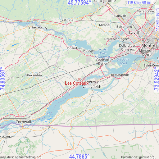
Les Coteaux GPS coordinates[2]
45° 17' 0.168" North, 74° 13' 57.144" West
| Map corner | latitude | longitude |
|---|---|---|
| Upper-left | 45.77594°, | -74.93567° |
| Center: | 45.28338°, | -74.23254° |
| Lower-right: | 44.7865°, | -73.52942° |
| Map W x H: | 110×110 km | = 68.4×68.4mi |
| max Lat: | 73.03752° ⇑81.4% North |
| Les Coteaux: | 45.28338° |
| min Lat: | ⇓18.6% South 42.05009° |
| min Long | Les Coteaux | max Long |
| -139.43328° | -74.23254° | -52.70931° |
| W 60.4%⇐ | ⇒39.6% E |
Elevation
Elevation of Les Coteaux is 44 m = 144 ft, and this is 210.4 m = 690 ft below average elevation for this country.
| Max E: |
1518 m = 4980 ft | 74.7% |
| Avg. | 254.4 m = 835 ft | |
| Les Coteaux | 44 m = 144 ft | |
Min E: |
-2 m = -7 ft | 25.3% |
See also: Canada elevation on elevation.city.
Geographical zone
Les Coteaux is located in North temperate zone (between Tropic of Cancer and the Arctic Circle). Distance of this North polar circle is 2366.1 km =1470.2 mi to North.| Distance of | km | miles | from Les Coteaux |
|---|---|---|---|
| North Pole | 4972 | 3089.5 | to North |
| Arctic Circle | 2366.1 | 1470.2 | to North |
| Tropic Cancer | 2429.1 | 1509.4 | to South |
| Equator | 5035 | 3128.6 | to South |


Nearby cities:
15 places around Les Coteaux: (largest is in red/bold)
• Coteau-du-Lac
4.3 km =2.7 mi,  64°
64°
• Hudson
19.6 km =12.2 mi,  19°
19°
• Huntingdon
22.8 km =14.2 mi,  166°
166°
• Les Cèdres
14.5 km =9 mi,  82°
82°
• Melocheville
23.4 km =14.5 mi, 80°
• Oka
23.1 km =14.4 mi,  29°
29°
• Pincourt
22.5 km =14 mi, 60°
• Rigaud
22.5 km =14 mi,  345°
345°
• Saint-Jean-Baptiste
20.3 km =12.6 mi, 57°
• Saint-Lazare
15.1 km =9.4 mi, 31°
• Saint-Polycarpe
5.5 km =3.4 mi,  289°
289°
• Saint-Zotique
3.9 km =2.4 mi,  199°
199°
• Salaberry-de-Valleyfield
8.7 km =5.4 mi,  115°
115°
• Très-Saint-Rédempteur
20.4 km =12.7 mi,  324°
324°
• Vaudreuil-Dorion
20.3 km =12.6 mi,  50°
50°
Sources, notices
• [Note1] Compared only with cities in Canada existing in our database
• [Src1] Map data: © OpenStreetMap contributors (CC-BY-SA)
• [Src2] Other city data from geonames.org with taken over terms of usage.
• [Src3] Geographical zone / Annual Mean Temperature by Robert A. Rohde @ Wikipedia
