Salaberry-de-Valleyfield geodata
Salaberry-de-Valleyfield (Quebec) is a populated place; located in Canada in America/Toronto (GMT-4) time zone. With population of 38,662 people, there are 122 cities with bigger population in this country. Compared to other cities in Canada, 82% of cities are located further ↑North; 61.2% of cities are located further ←West and 73.8% of cities have higher elevation than Salaberry-de-Valleyfield. Note1
Current local time in Salaberry-de-Valleyfield:
03:42 AM, MondayDifference from your time zone: hours


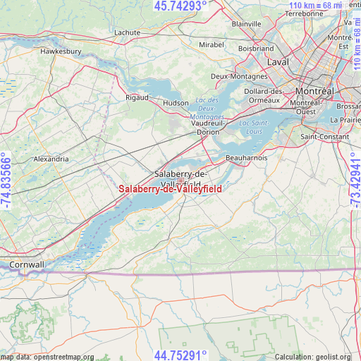
Salaberry-de-Valleyfield GPS coordinates[2]
45° 15' 0.288" North, 74° 7' 57.108" West
| Map corner | latitude | longitude |
|---|---|---|
| Upper-left | 45.74293°, | -74.83566° |
| Center: | 45.25008°, | -74.13253° |
| Lower-right: | 44.75291°, | -73.42941° |
| Map W x H: | 110.1×110.1 km | = 68.4×68.4mi |
| max Lat: | 73.03752° ⇑82% North |
| Salaberry-de-Valleyfield: | 45.25008° |
| min Lat: | ⇓18% South 42.05009° |
| min Long | Salaberry-de-Va | max Long |
| -139.43328° | -74.13253° | -52.70931° |
| W 61.2%⇐ | ⇒38.8% E |
Elevation
Elevation of Salaberry-de-Valleyfield is 46 m = 151 ft, and this is 208.4 m = 684 ft below average elevation for this country.
| Max E: |
1518 m = 4980 ft | 73.8% |
| Avg. | 254.4 m = 835 ft | |
| Salaberry-de-Valleyfield | 46 m = 151 ft | |
Min E: |
-2 m = -7 ft | 26.2% |
See also: Canada elevation on elevation.city.
Geographical zone
Salaberry-de-Valleyfield is located in North temperate zone (between Tropic of Cancer and the Arctic Circle). Distance of this North polar circle is 2369.8 km =1472.5 mi to North.| Distance of | km | miles | from Salaberry-de-Valleyfield |
|---|---|---|---|
| North Pole | 4975.7 | 3091.8 | to North |
| Arctic Circle | 2369.8 | 1472.5 | to North |
| Tropic Cancer | 2425.4 | 1507.1 | to South |
| Equator | 5031.3 | 3126.3 | to South |


Nearby cities:
15 places around Salaberry-de-Valleyfield: (largest is in red/bold)
• Beauharnois
21.5 km =13.4 mi,  70°
70°
• Coteau-du-Lac
6.8 km =4.2 mi,  324°
324°
• Huntingdon
18.7 km =11.6 mi,  188°
188°
• L'Île-Perrot
20.6 km =12.8 mi,  44°
44°
• Les Coteaux
8.7 km =5.4 mi,  295°
295°
• Les Cèdres
8.6 km =5.3 mi,  49°
49°
• Melocheville
17 km =10.6 mi,  63°
63°
• Notre-Dame-de-l'Île-Perrot
20.3 km =12.6 mi, 50°
• Ormstown
16.7 km =10.4 mi,  141°
141°
• Pincourt
18.9 km =11.7 mi, 38°
• Saint-Jean-Baptiste
17.3 km =10.7 mi,  32°
32°
• Saint-Lazare
16.7 km =10.4 mi,  359°
359°
• Saint-Polycarpe
14.2 km =8.8 mi,  293°
293°
• Saint-Zotique
9.1 km =5.7 mi,  270°
270°
• Vaudreuil-Dorion
18.4 km =11.4 mi, 25°
Sources, notices
• [Note1] Compared only with cities in Canada existing in our database
• [Src1] Map data: © OpenStreetMap contributors (CC-BY-SA)
• [Src2] Other city data from geonames.org with taken over terms of usage.
• [Src3] Geographical zone / Annual Mean Temperature by Robert A. Rohde @ Wikipedia
