Rigaud geodata
Rigaud (Quebec) is a populated place; located in Canada in America/Toronto (GMT-4) time zone. With population of 3,613 people, there are 563 cities with bigger population in this country. Compared to other cities in Canada, 75.3% of cities are located further ↑North; 59.9% of cities are located further ←West and 81.3% of cities have higher elevation than Rigaud. Note1


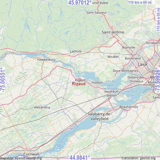
Rigaud GPS coordinates[2]
45° 28' 45.372" North, 74° 18' 8.568" West
| Map corner | latitude | longitude |
|---|---|---|
| Upper-left | 45.97012°, | -75.00551° |
| Center: | 45.47927°, | -74.30238° |
| Lower-right: | 44.9841°, | -73.59926° |
| Map W x H: | 109.6×109.6 km | = 68.1×68.1mi |
| max Lat: | 73.03752° ⇑75.3% North |
| Rigaud: | 45.47927° |
| min Lat: | ⇓24.7% South 42.05009° |
| min Long | Rigaud | max Long |
| -139.43328° | -74.30238° | -52.70931° |
| W 59.9%⇐ | ⇒40.1% E |
Elevation
Elevation of Rigaud is 30 m = 98 ft, and this is 224.4 m = 736 ft below average elevation for this country.
| Max E: |
1518 m = 4980 ft | 81.3% |
| Avg. | 254.4 m = 835 ft | |
| Rigaud | 30 m = 98 ft | |
Min E: |
-2 m = -7 ft | 18.7% |
See also: Canada elevation on elevation.city.
Geographical zone
Rigaud is located in North temperate zone (between Tropic of Cancer and the Arctic Circle). Distance of this North polar circle is 2344.4 km =1456.7 mi to North.| Distance of | km | miles | from Rigaud |
|---|---|---|---|
| North Pole | 4950.2 | 3075.9 | to North |
| Arctic Circle | 2344.4 | 1456.7 | to North |
| Tropic Cancer | 2450.9 | 1522.9 | to South |
| Equator | 5056.8 | 3142.1 | to South |


Nearby cities:
15 places around Rigaud: (largest is in red/bold)
• Brownsburg-Chatham
24.4 km =15.2 mi,  338°
338°
• Coteau-du-Lac
22 km =13.7 mi,  154°
154°
• Hudson
12.4 km =7.7 mi,  105°
105°
• Lachute
19.1 km =11.9 mi,  352°
352°
• Les Coteaux
22.5 km =14 mi,  165°
165°
• Mirabel
25.6 km =15.9 mi,  42°
42°
• Oka
16.7 km =10.4 mi,  95°
95°
• Pointe-Calumet
26.3 km =16.3 mi,  84°
84°
• Saint-Jean-Baptiste
25.2 km =15.7 mi,  115°
115°
• Saint-Joseph-du-Lac
24.4 km =15.2 mi, 75°
• Saint-Lazare
15.9 km =9.9 mi, 123°
• Saint-Polycarpe
19.9 km =12.4 mi,  179°
179°
• Saint-Zotique
25.8 km =16 mi, 170°
• Très-Saint-Rédempteur
8.1 km =5 mi,  230°
230°
• Vaudreuil-Dorion
22.8 km =14.2 mi, 112°
Sources, notices
• [Note1] Compared only with cities in Canada existing in our database
• [Src1] Map data: © OpenStreetMap contributors (CC-BY-SA)
• [Src2] Other city data from geonames.org with taken over terms of usage.
• [Src3] Geographical zone / Annual Mean Temperature by Robert A. Rohde @ Wikipedia
