Lloydminster geodata
Lloydminster (Alberta) is a seat of a second-order administrative division; located in Canada in America/Edmonton (GMT-6) time zone. With population of 31,400 people, there are 141 cities with bigger population in this country. Compared to other cities in Canada, 90.1% of cities are located further ↓South; 74.8% of cities are located further →East and 88.9% of cities have lower elevation than Lloydminster. Note1


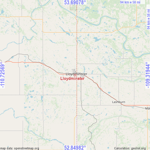
Lloydminster GPS coordinates[2]
53° 16' 20.532" North, 110° 1' 21.216" West
| Map corner | latitude | longitude |
|---|---|---|
| Upper-left | 53.69078°, | -110.72569° |
| Center: | 53.27237°, | -110.02256° |
| Lower-right: | 52.84982°, | -109.31944° |
| Map W x H: | 93.5×93.5 km | = 58.1×58.1mi |
| max Lat: | 73.03752° ⇑9.9% North |
| Lloydminster: | 53.27237° |
| min Lat: | ⇓90.1% South 42.05009° |
| min Long | Lloydminster | max Long |
| -139.43328° | -110.02256° | -52.70931° |
| W 25.2%⇐ | ⇒74.8% E |
Elevation
Elevation of Lloydminster is 652 m = 2139 ft, and this is 397.6 m = 1304 ft above average elevation for this country.
| Max E: |
1518 m = 4980 ft | 11.1% |
| Lloydminster | 652 m 2139 ft | |
| Avg. | 254.4 m = 835 ft | |
Min E: |
-2 m = -7 ft | 88.9% |
See also: Canada elevation on elevation.city.
Geographical zone
Lloydminster is located in North temperate zone (between Tropic of Cancer and the Arctic Circle). Distance of this North polar circle is 1477.8 km =918.3 mi to North.| Distance of | km | miles | from Lloydminster |
|---|---|---|---|
| North Pole | 4083.7 | 2537.5 | to North |
| Arctic Circle | 1477.8 | 918.3 | to North |
| Tropic Cancer | 3317.4 | 2061.3 | to South |
| Equator | 5923.3 | 3680.6 | to South |


Nearby cities:
15 places around Lloydminster: (largest is in red/bold)
• Bonnyville
120.1 km =74.6 mi,  337°
337°
• Cold Lake
133 km =82.6 mi,  355°
355°
• Elk Point
90.8 km =56.4 mi,  320°
320°
• Grand Centre
127.8 km =79.4 mi,  354°
354°
• Macklin
104.6 km =65 mi,  176°
176°
• Mannville
76.4 km =47.5 mi,  275°
275°
• North Battleford
127.8 km =79.4 mi,  115°
115°
• Provost
103.9 km =64.6 mi,  189°
189°
• St. Paul
114.8 km =71.3 mi,  313°
313°
• Two Hills
124.6 km =77.4 mi,  293°
293°
• Unity
107.9 km =67 mi,  147°
147°
• Vermilion
56.3 km =35 mi, 279°
• Viking
117.9 km =73.3 mi,  260°
260°
• Wainwright
73.8 km =45.9 mi,  228°
228°
• Wilkie
130.1 km =80.8 mi,  136°
136°
Sources, notices
• [Note1] Compared only with cities in Canada existing in our database
• [Src1] Map data: © OpenStreetMap contributors (CC-BY-SA)
• [Src2] Other city data from geonames.org with taken over terms of usage.
• [Src3] Geographical zone / Annual Mean Temperature by Robert A. Rohde @ Wikipedia
