Provost geodata
Provost (Alberta) is a populated place; located in Canada in America/Edmonton (GMT-6) time zone. With population of 2,082 people, there are 735 cities with bigger population in this country. Compared to other cities in Canada, 87.5% of cities are located further ↓South; 75.1% of cities are located further →East and 90.1% of cities have lower elevation than Provost. Note1


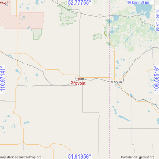
Provost GPS coordinates[2]
52° 21' 0.504" North, 110° 16' 5.808" West
| Map corner | latitude | longitude |
|---|---|---|
| Upper-left | 52.77755°, | -110.97141° |
| Center: | 52.35014°, | -110.26828° |
| Lower-right: | 51.91856°, | -109.56516° |
| Map W x H: | 95.5×95.5 km | = 59.3×59.3mi |
| max Lat: | 73.03752° ⇑12.5% North |
| Provost: | 52.35014° |
| min Lat: | ⇓87.5% South 42.05009° |
| min Long | Provost | max Long |
| -139.43328° | -110.26828° | -52.70931° |
| W 24.9%⇐ | ⇒75.1% E |
Elevation
Elevation of Provost is 666 m = 2185 ft, and this is 411.6 m = 1350 ft above average elevation for this country.
| Max E: |
1518 m = 4980 ft | 9.9% |
| Provost | 666 m 2185 ft | |
| Avg. | 254.4 m = 835 ft | |
Min E: |
-2 m = -7 ft | 90.1% |
See also: Canada elevation on elevation.city.
Geographical zone
Provost is located in North temperate zone (between Tropic of Cancer and the Arctic Circle). Distance of this North polar circle is 1580.4 km =982 mi to North.| Distance of | km | miles | from Provost |
|---|---|---|---|
| North Pole | 4186.3 | 2601.2 | to North |
| Arctic Circle | 1580.4 | 982 | to North |
| Tropic Cancer | 3214.9 | 1997.6 | to South |
| Equator | 5820.8 | 3616.9 | to South |


Nearby cities:
15 places around Provost: (largest is in red/bold)
• Biggar
157.6 km =97.9 mi,  101°
101°
• Hanna
137.3 km =85.3 mi,  234°
234°
• Kerrobert
91.1 km =56.6 mi,  121°
121°
• Killam
117.4 km =72.9 mi,  294°
294°
• Kindersley
123.9 km =77 mi,  142°
142°
• Lloydminster
103.9 km =64.6 mi,  9°
9°
• Macklin
22.7 km =14.1 mi,  94°
94°
• Mannville
124.9 km =77.6 mi,  331°
331°
• North Battleford
141.6 km =88 mi,  70°
70°
• Stettler
166.5 km =103.5 mi,  268°
268°
• Unity
75.5 km =46.9 mi,  81°
81°
• Vermilion
118.5 km =73.6 mi,  340°
340°
• Viking
131 km =81.4 mi,  309°
309°
• Wainwright
66.8 km =41.5 mi,  323°
323°
• Wilkie
106.6 km =66.2 mi, 86°
Sources, notices
• [Note1] Compared only with cities in Canada existing in our database
• [Src1] Map data: © OpenStreetMap contributors (CC-BY-SA)
• [Src2] Other city data from geonames.org with taken over terms of usage.
• [Src3] Geographical zone / Annual Mean Temperature by Robert A. Rohde @ Wikipedia
