Wainwright geodata
Wainwright (Alberta) is a populated place; located in Canada in America/Edmonton (GMT-6) time zone. With population of 5,380 people, there are 458 cities with bigger population in this country. Compared to other cities in Canada, 88.6% of cities are located further ↓South; 75.3% of cities are located further →East and 90.7% of cities have lower elevation than Wainwright. Note1


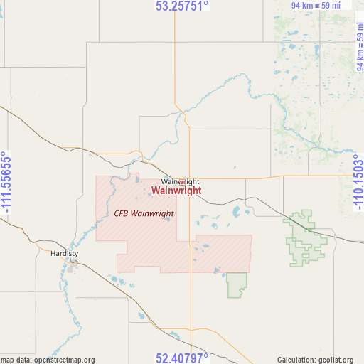
Wainwright GPS coordinates[2]
52° 50' 5.352" North, 110° 51' 12.312" West
| Map corner | latitude | longitude |
|---|---|---|
| Upper-left | 53.25751°, | -111.55655° |
| Center: | 52.83482°, | -110.85342° |
| Lower-right: | 52.40797°, | -110.1503° |
| Map W x H: | 94.5×94.5 km | = 58.7×58.7mi |
| max Lat: | 73.03752° ⇑11.4% North |
| Wainwright: | 52.83482° |
| min Lat: | ⇓88.6% South 42.05009° |
| min Long | Wainwright | max Long |
| -139.43328° | -110.85342° | -52.70931° |
| W 24.7%⇐ | ⇒75.3% E |
Elevation
Elevation of Wainwright is 680 m = 2231 ft, and this is 425.6 m = 1396 ft above average elevation for this country.
| Max E: |
1518 m = 4980 ft | 9.3% |
| Wainwright | 680 m 2231 ft | |
| Avg. | 254.4 m = 835 ft | |
Min E: |
-2 m = -7 ft | 90.7% |
See also: Canada elevation on elevation.city.
Geographical zone
Wainwright is located in North temperate zone (between Tropic of Cancer and the Arctic Circle). Distance of this North polar circle is 1526.5 km =948.5 mi to North.| Distance of | km | miles | from Wainwright |
|---|---|---|---|
| North Pole | 4132.4 | 2567.8 | to North |
| Arctic Circle | 1526.5 | 948.5 | to North |
| Tropic Cancer | 3268.8 | 2031.1 | to South |
| Equator | 5874.7 | 3650.4 | to South |


Nearby cities:
15 places around Wainwright: (largest is in red/bold)
• Camrose
134.4 km =83.5 mi,  278°
278°
• Elk Point
118.5 km =73.6 mi,  358°
358°
• Killam
67.3 km =41.8 mi,  265°
265°
• Lloydminster
73.8 km =45.9 mi,  48°
48°
• Macklin
83.4 km =51.8 mi,  131°
131°
• Mannville
59.3 km =36.8 mi,  339°
339°
• Provost
66.8 km =41.5 mi,  143°
143°
• St. Paul
130.9 km =81.3 mi,  347°
347°
• Stettler
138.6 km =86.1 mi,  245°
245°
• Tofield
134.8 km =83.8 mi,  296°
296°
• Two Hills
114.8 km =71.3 mi,  328°
328°
• Unity
121.5 km =75.5 mi,  110°
110°
• Vegreville
108.9 km =67.7 mi,  312°
312°
• Vermilion
57.7 km =35.9 mi, 359°
• Viking
68 km =42.3 mi, 295°
Sources, notices
• [Note1] Compared only with cities in Canada existing in our database
• [Src1] Map data: © OpenStreetMap contributors (CC-BY-SA)
• [Src2] Other city data from geonames.org with taken over terms of usage.
• [Src3] Geographical zone / Annual Mean Temperature by Robert A. Rohde @ Wikipedia
