Bonnyville geodata
Bonnyville (Alberta) is a populated place; located in Canada in America/Edmonton (GMT-6) time zone. With population of 6,003 people, there are 432 cities with bigger population in this country. Compared to other cities in Canada, 93.9% of cities are located further ↓South; 75.3% of cities are located further →East and 84.5% of cities have lower elevation than Bonnyville. Note1


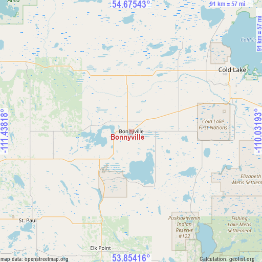
Bonnyville GPS coordinates[2]
54° 16' 0.624" North, 110° 44' 6.18" West
| Map corner | latitude | longitude |
|---|---|---|
| Upper-left | 54.67543°, | -111.43818° |
| Center: | 54.26684°, | -110.73505° |
| Lower-right: | 53.85416°, | -110.03193° |
| Map W x H: | 91.3×91.3 km | = 56.7×56.7mi |
| max Lat: | 73.03752° ⇑6.1% North |
| Bonnyville: | 54.26684° |
| min Lat: | ⇓93.9% South 42.05009° |
| min Long | Bonnyville | max Long |
| -139.43328° | -110.73505° | -52.70931° |
| W 24.7%⇐ | ⇒75.3% E |
Elevation
Elevation of Bonnyville is 555 m = 1821 ft, and this is 300.6 m = 986 ft above average elevation for this country.
| Max E: |
1518 m = 4980 ft | 15.5% |
| Bonnyville | 555 m 1821 ft | |
| Avg. | 254.4 m = 835 ft | |
Min E: |
-2 m = -7 ft | 84.5% |
See also: Canada elevation on elevation.city.
Geographical zone
Bonnyville is located in North temperate zone (between Tropic of Cancer and the Arctic Circle). Distance of this North polar circle is 1367.3 km =849.6 mi to North.| Distance of | km | miles | from Bonnyville |
|---|---|---|---|
| North Pole | 3973.2 | 2468.8 | to North |
| Arctic Circle | 1367.3 | 849.6 | to North |
| Tropic Cancer | 3428 | 2130.1 | to South |
| Equator | 6033.9 | 3749.3 | to South |


Nearby cities:
15 places around Bonnyville: (largest is in red/bold)
• Cold Lake
42.1 km =26.2 mi,  58°
58°
• Elk Point
42.2 km =26.2 mi,  194°
194°
• Grand Centre
37.7 km =23.4 mi, 63°
• Lac La Biche
97.1 km =60.3 mi,  304°
304°
• Lamont
146 km =90.7 mi,  247°
247°
• Lloydminster
120.1 km =74.6 mi,  157°
157°
• Mannville
107.6 km =66.9 mi,  195°
195°
• Meadow Lake
150.3 km =93.4 mi,  95°
95°
• Smoky Lake
114 km =70.8 mi,  261°
261°
• St. Paul
47.7 km =29.6 mi,  228°
228°
• Two Hills
90.3 km =56.1 mi, 227°
• Vegreville
121.3 km =75.4 mi, 225°
• Vermilion
101.8 km =63.3 mi,  184°
184°
• Viking
146.5 km =91 mi,  207°
207°
• Wainwright
159.4 km =99 mi, 182°
Sources, notices
• [Note1] Compared only with cities in Canada existing in our database
• [Src1] Map data: © OpenStreetMap contributors (CC-BY-SA)
• [Src2] Other city data from geonames.org with taken over terms of usage.
• [Src3] Geographical zone / Annual Mean Temperature by Robert A. Rohde @ Wikipedia
