Princeton geodata
Princeton (British Columbia) is a populated place; located in Canada in America/Vancouver (GMT-7) time zone. With population of 2,706 people, there are 648 cities with bigger population in this country. Compared to other cities in Canada, 69.7% of cities are located further ↓South; 89.5% of cities are located further →East and 89.6% of cities have lower elevation than Princeton. Note1
Administrative division(s):
- Level 1: British Columbia
- Level 2: Regional District of Okanagan-Similkameen
- Level 3: Princeton


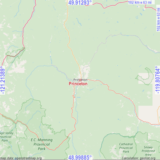
Princeton GPS coordinates[2]
49° 27' 28.872" North, 120° 30' 38.736" West
| Map corner | latitude | longitude |
|---|---|---|
| Upper-left | 49.91293°, | -121.21389° |
| Center: | 49.45802°, | -120.51076° |
| Lower-right: | 48.99885°, | -119.80764° |
| Map W x H: | 101.6×101.6 km | = 63.1×63.1mi |
| max Lat: | 73.03752° ⇑30.3% North |
| Princeton: | 49.45802° |
| min Lat: | ⇓69.7% South 42.05009° |
| min Long | Princeton | max Long |
| -139.43328° | -120.51076° | -52.70931° |
| W 10.5%⇐ | ⇒89.5% E |
Elevation
Elevation of Princeton is 660 m = 2165 ft, and this is 405.6 m = 1331 ft above average elevation for this country.
| Max E: |
1518 m = 4980 ft | 10.4% |
| Princeton | 660 m 2165 ft | |
| Avg. | 254.4 m = 835 ft | |
Min E: |
-2 m = -7 ft | 89.6% |
See also: Canada elevation on elevation.city.
Geographical zone
Princeton is located in North temperate zone (between Tropic of Cancer and the Arctic Circle). Distance of this North polar circle is 1902 km =1181.8 mi to North.| Distance of | km | miles | from Princeton |
|---|---|---|---|
| North Pole | 4507.8 | 2801 | to North |
| Arctic Circle | 1902 | 1181.8 | to North |
| Tropic Cancer | 2893.3 | 1797.8 | to South |
| Equator | 5499.2 | 3417 | to South |


Nearby cities:
15 places around Princeton: (largest is in red/bold)
• Agassiz
94.5 km =58.7 mi,  254°
254°
• Bell Acres
107.1 km =66.5 mi, 246°
• Chilliwack
109.4 km =68 mi, 252°
• Duck Lake
100.8 km =62.6 mi,  52°
52°
• Ellison
97.6 km =60.6 mi,  57°
57°
• Hope
67.8 km =42.1 mi,  262°
262°
• Kelowna
87.6 km =54.4 mi, 57°
• Merritt
75.5 km =46.9 mi,  344°
344°
• Okanagan Falls
69.4 km =43.1 mi,  99°
99°
• Oliver
75.9 km =47.2 mi,  113°
113°
• Osoyoos
90.2 km =56 mi,  121°
121°
• Peachland
65.5 km =40.7 mi, 58°
• Penticton
66.9 km =41.6 mi,  87°
87°
• Summerland
62.8 km =39 mi,  75°
75°
• West Kelowna
80.5 km =50 mi, 56°
Sources, notices
• [Note1] Compared only with cities in Canada existing in our database
• [Src1] Map data: © OpenStreetMap contributors (CC-BY-SA)
• [Src2] Other city data from geonames.org with taken over terms of usage.
• [Src3] Geographical zone / Annual Mean Temperature by Robert A. Rohde @ Wikipedia
