Oliver geodata
Oliver (British Columbia) is a populated place; located in Canada in America/Vancouver (GMT-7) time zone. With population of 5,279 people, there are 462 cities with bigger population in this country. Compared to other cities in Canada, 65.5% of cities are located further ↓South; 88.6% of cities are located further →East and 70.7% of cities have lower elevation than Oliver. Note1
Administrative division(s):
- Level 1: British Columbia
- Level 2: Regional District of Okanagan-Similkameen
- Level 3: Oliver


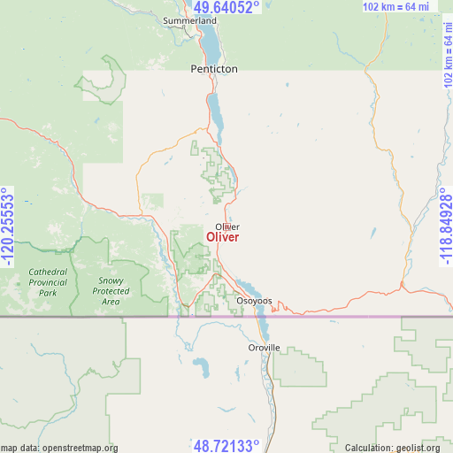
Oliver GPS coordinates[2]
49° 10' 59.016" North, 119° 33' 8.64" West
| Map corner | latitude | longitude |
|---|---|---|
| Upper-left | 49.64052°, | -120.25553° |
| Center: | 49.18306°, | -119.5524° |
| Lower-right: | 48.72133°, | -118.84928° |
| Map W x H: | 102.2×102.2 km | = 63.5×63.5mi |
| max Lat: | 73.03752° ⇑34.5% North |
| Oliver: | 49.18306° |
| min Lat: | ⇓65.5% South 42.05009° |
| min Long | Oliver | max Long |
| -139.43328° | -119.5524° | -52.70931° |
| W 11.4%⇐ | ⇒88.6% E |
Elevation
Elevation of Oliver is 309 m = 1014 ft, and this is 54.6 m = 179 ft above average elevation for this country.
| Max E: |
1518 m = 4980 ft | 29.3% |
| Oliver | 309 m 1014 ft | |
| Avg. | 254.4 m = 835 ft | |
Min E: |
-2 m = -7 ft | 70.7% |
See also: Canada elevation on elevation.city.
Geographical zone
Oliver is located in North temperate zone (between Tropic of Cancer and the Arctic Circle). Distance of this North polar circle is 1932.5 km =1200.8 mi to North.| Distance of | km | miles | from Oliver |
|---|---|---|---|
| North Pole | 4538.4 | 2820 | to North |
| Arctic Circle | 1932.5 | 1200.8 | to North |
| Tropic Cancer | 2862.7 | 1778.8 | to South |
| Equator | 5468.6 | 3398 | to South |


Nearby cities:
15 places around Oliver: (largest is in red/bold)
• Duck Lake
92.5 km =57.5 mi,  6°
6°
• Ellison
84.4 km =52.4 mi, 9°
• Grand Forks
83 km =51.6 mi,  101°
101°
• Kelowna
78 km =48.5 mi,  3°
3°
• Lumby
125.8 km =78.2 mi,  19°
19°
• Okanagan Falls
18.6 km =11.6 mi,  356°
356°
• Osoyoos
18.2 km =11.3 mi,  156°
156°
• Peachland
66.2 km =41.1 mi,  348°
348°
• Penticton
33.2 km =20.6 mi, 355°
• Princeton
75.9 km =47.2 mi,  293°
293°
• Rossland
127.8 km =79.4 mi,  94°
94°
• Sion
79.4 km =49.3 mi, 103°
• Summerland
47.1 km =29.3 mi, 349°
• Vernon
122.2 km =75.9 mi, 9°
• West Kelowna
75.6 km =47 mi, 358°
Sources, notices
• [Note1] Compared only with cities in Canada existing in our database
• [Src1] Map data: © OpenStreetMap contributors (CC-BY-SA)
• [Src2] Other city data from geonames.org with taken over terms of usage.
• [Src3] Geographical zone / Annual Mean Temperature by Robert A. Rohde @ Wikipedia
