Saint-Lin-Laurentides geodata
Saint-Lin-Laurentides (Quebec) is a populated place; located in Canada in America/Toronto (GMT-4) time zone. With population of 14,159 people, there are 253 cities with bigger population in this country. Compared to other cities in Canada, 66.9% of cities are located further ↑North; 65.2% of cities are located further ←West and 68.9% of cities have higher elevation than Saint-Lin-Laurentides. Note1


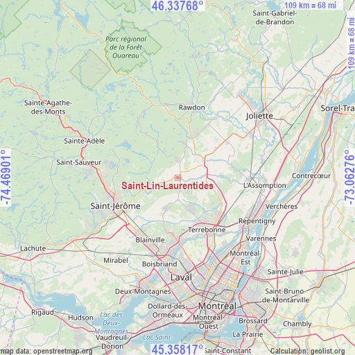
Saint-Lin-Laurentides GPS coordinates[2]
45° 51' 0.288" North, 73° 45' 57.168" West
| Map corner | latitude | longitude |
|---|---|---|
| Upper-left | 46.33768°, | -74.46901° |
| Center: | 45.85008°, | -73.76588° |
| Lower-right: | 45.35817°, | -73.06276° |
| Map W x H: | 108.9×108.9 km | = 67.7×67.7mi |
| max Lat: | 73.03752° ⇑66.9% North |
| Saint-Lin-Laurentides: | 45.85008° |
| min Lat: | ⇓33.1% South 42.05009° |
| min Long | Saint-Lin-Laure | max Long |
| -139.43328° | -73.76588° | -52.70931° |
| W 65.2%⇐ | ⇒34.8% E |
Elevation
Elevation of Saint-Lin-Laurentides is 59 m = 194 ft, and this is 195.4 m = 641 ft below average elevation for this country.
| Max E: |
1518 m = 4980 ft | 68.9% |
| Avg. | 254.4 m = 835 ft | |
| Saint-Lin-Laurentides | 59 m = 194 ft | |
Min E: |
-2 m = -7 ft | 31.1% |
See also: Canada elevation on elevation.city.
Geographical zone
Saint-Lin-Laurentides is located in North temperate zone (between Tropic of Cancer and the Arctic Circle). Distance of this North polar circle is 2303.1 km =1431.1 mi to North.| Distance of | km | miles | from Saint-Lin-Laurentides |
|---|---|---|---|
| North Pole | 4909 | 3050.3 | to North |
| Arctic Circle | 2303.1 | 1431.1 | to North |
| Tropic Cancer | 2492.1 | 1548.5 | to South |
| Equator | 5098.1 | 3167.8 | to South |


Nearby cities:
15 places around Saint-Lin-Laurentides: (largest is in red/bold)
• Blainville
22.3 km =13.9 mi,  203°
203°
• Bois-des-Filion
20.4 km =12.7 mi,  176°
176°
• L'Épiphanie
22 km =13.7 mi,  90°
90°
• Lac-Alouette
15.4 km =9.6 mi,  256°
256°
• Lac-Connelly
16.8 km =10.4 mi,  288°
288°
• Lac-Lapierre
5.4 km =3.4 mi,  354°
354°
• Lorraine
18.6 km =11.6 mi, 183°
• Mascouche
17.1 km =10.6 mi,  130°
130°
• Saint-Hippolyte
21.5 km =13.4 mi,  295°
295°
• Saint-Jacques
18.7 km =11.6 mi,  54°
54°
• Saint-Jérôme
20 km =12.4 mi,  247°
247°
• Sainte-Anne-des-Plaines
10.1 km =6.3 mi, 200°
• Sainte-Julienne
13.5 km =8.4 mi,  16°
16°
• Sainte-Sophie
11 km =6.8 mi, 250°
• Terrebonne
19 km =11.8 mi,  151°
151°
Sources, notices
• [Note1] Compared only with cities in Canada existing in our database
• [Src1] Map data: © OpenStreetMap contributors (CC-BY-SA)
• [Src2] Other city data from geonames.org with taken over terms of usage.
• [Src3] Geographical zone / Annual Mean Temperature by Robert A. Rohde @ Wikipedia
