Brownsburg-Chatham geodata
Brownsburg-Chatham (Quebec) is a populated place; located in Canada in America/Toronto (GMT-4) time zone. With population of 6,664 people, there are 412 cities with bigger population in this country. Compared to other cities in Canada, 69.4% of cities are located further ↑North; 59.3% of cities are located further ←West and 52.5% of cities have higher elevation than Brownsburg-Chatham. Note1


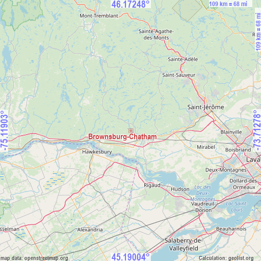
Brownsburg-Chatham GPS coordinates[2]
45° 41' 0.312" North, 74° 24' 57.24" West
| Map corner | latitude | longitude |
|---|---|---|
| Upper-left | 46.17248°, | -75.11903° |
| Center: | 45.68342°, | -74.4159° |
| Lower-right: | 45.19004°, | -73.71278° |
| Map W x H: | 109.2×109.2 km | = 67.9×67.9mi |
| max Lat: | 73.03752° ⇑69.4% North |
| Brownsburg-Chatham: | 45.68342° |
| min Lat: | ⇓30.6% South 42.05009° |
| min Long | Brownsburg-Chat | max Long |
| -139.43328° | -74.4159° | -52.70931° |
| W 59.3%⇐ | ⇒40.7% E |
Elevation
Elevation of Brownsburg-Chatham is 157 m = 515 ft, and this is 97.4 m = 320 ft below average elevation for this country.
| Max E: |
1518 m = 4980 ft | 52.5% |
| Avg. | 254.4 m = 835 ft | |
| Brownsburg-Chatham | 157 m = 515 ft | |
Min E: |
-2 m = -7 ft | 47.5% |
See also: Canada elevation on elevation.city.
Geographical zone
Brownsburg-Chatham is located in North temperate zone (between Tropic of Cancer and the Arctic Circle). Distance of this North polar circle is 2321.7 km =1442.6 mi to North.| Distance of | km | miles | from Brownsburg-Chatham |
|---|---|---|---|
| North Pole | 4927.5 | 3061.8 | to North |
| Arctic Circle | 2321.7 | 1442.6 | to North |
| Tropic Cancer | 2473.6 | 1537 | to South |
| Equator | 5079.5 | 3156.3 | to South |


Nearby cities:
15 places around Brownsburg-Chatham: (largest is in red/bold)
• Calumet
17.4 km =10.8 mi,  258°
258°
• Hawkesbury
18.1 km =11.2 mi,  239°
239°
• L'Orignal
22.6 km =14 mi,  251°
251°
• Lachute
7.5 km =4.7 mi,  119°
119°
• Mirabel
26.2 km =16.3 mi,  98°
98°
• Morin-Heights
27.3 km =17 mi,  28°
28°
• Piedmont
32.6 km =20.3 mi,  42°
42°
• Prévost
32.9 km =20.4 mi,  51°
51°
• Rigaud
24.4 km =15.2 mi,  158°
158°
• Saint-Adolphe-d'Howard
32.2 km =20 mi,  11°
11°
• Saint-Canut
26 km =16.2 mi,  82°
82°
• Saint-Colomban
22.7 km =14.1 mi, 75°
• Saint-Sauveur
29.1 km =18.1 mi, 39°
• Saint-Sauveur-des-Monts
30.9 km =19.2 mi, 38°
• Très-Saint-Rédempteur
27.9 km =17.3 mi,  174°
174°
Sources, notices
• [Note1] Compared only with cities in Canada existing in our database
• [Src1] Map data: © OpenStreetMap contributors (CC-BY-SA)
• [Src2] Other city data from geonames.org with taken over terms of usage.
• [Src3] Geographical zone / Annual Mean Temperature by Robert A. Rohde @ Wikipedia
