Saint-Adolphe-d'Howard geodata
Saint-Adolphe-d'Howard (Quebec) is a populated place; located in Canada in America/Toronto (GMT-4) time zone. With population of 3,702 people, there are 554 cities with bigger population in this country. Compared to other cities in Canada, 63.7% of cities are located further ↑North; 59.8% of cities are located further ←West and 76.1% of cities have lower elevation than Saint-Adolphe-d'Howard. Note1


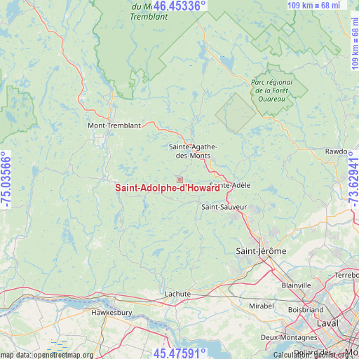
Saint-Adolphe-d'Howard GPS coordinates[2]
45° 58' 0.444" North, 74° 19' 57.108" West
| Map corner | latitude | longitude |
|---|---|---|
| Upper-left | 46.45336°, | -75.03566° |
| Center: | 45.96679°, | -74.33253° |
| Lower-right: | 45.47591°, | -73.62941° |
| Map W x H: | 108.7×108.7 km | = 67.5×67.5mi |
| max Lat: | 73.03752° ⇑63.7% North |
| Saint-Adolphe-d'Howard: | 45.96679° |
| min Lat: | ⇓36.3% South 42.05009° |
| min Long | Saint-Adolphe-d | max Long |
| -139.43328° | -74.33253° | -52.70931° |
| W 59.8%⇐ | ⇒40.2% E |
Elevation
Elevation of Saint-Adolphe-d'Howard is 374 m = 1227 ft, and this is 119.6 m = 392 ft above average elevation for this country.
| Max E: |
1518 m = 4980 ft | 23.9% |
| Saint-Adolphe-d'Howard | 374 m 1227 ft | |
| Avg. | 254.4 m = 835 ft | |
Min E: |
-2 m = -7 ft | 76.1% |
See also: Canada elevation on elevation.city.
Geographical zone
Saint-Adolphe-d'Howard is located in North temperate zone (between Tropic of Cancer and the Arctic Circle). Distance of this North polar circle is 2290.1 km =1423 mi to North.| Distance of | km | miles | from Saint-Adolphe-d'Howard |
|---|---|---|---|
| North Pole | 4896 | 3042.2 | to North |
| Arctic Circle | 2290.1 | 1423 | to North |
| Tropic Cancer | 2505.1 | 1556.6 | to South |
| Equator | 5111 | 3175.8 | to South |


Nearby cities:
15 places around Saint-Adolphe-d'Howard: (largest is in red/bold)
• Brownsburg-Chatham
32.2 km =20 mi,  191°
191°
• Lac-Connelly
28.9 km =18 mi,  105°
105°
• Morin-Heights
9.8 km =6.1 mi,  139°
139°
• Piedmont
17.2 km =10.7 mi,  115°
115°
• Prévost
22.3 km =13.9 mi, 119°
• Saint-Colomban
30.2 km =18.8 mi,  149°
149°
• Saint-Faustin
20.3 km =12.6 mi,  325°
325°
• Saint-Hippolyte
24.8 km =15.4 mi,  98°
98°
• Saint-Sauveur
14.8 km =9.2 mi,  126°
126°
• Saint-Sauveur-des-Monts
14.9 km =9.3 mi, 119°
• Sainte-Adèle
15.6 km =9.7 mi, 96°
• Sainte-Agathe-des-Monts
10 km =6.2 mi,  22°
22°
• Terrasse-des-Pins
23.5 km =14.6 mi, 118°
• Val-David
11.7 km =7.3 mi,  50°
50°
• Val-Morin
12.2 km =7.6 mi,  72°
72°
Sources, notices
• [Note1] Compared only with cities in Canada existing in our database
• [Src1] Map data: © OpenStreetMap contributors (CC-BY-SA)
• [Src2] Other city data from geonames.org with taken over terms of usage.
• [Src3] Geographical zone / Annual Mean Temperature by Robert A. Rohde @ Wikipedia
