Boucherville geodata
Boucherville (Quebec) is a populated place; located in Canada in America/Toronto (GMT-4) time zone. With population of 39,062 people, there are 121 cities with bigger population in this country. Compared to other cities in Canada, 72.1% of cities are located further ↑North; 68.9% of cities are located further ←West and 89.1% of cities have higher elevation than Boucherville. Note1


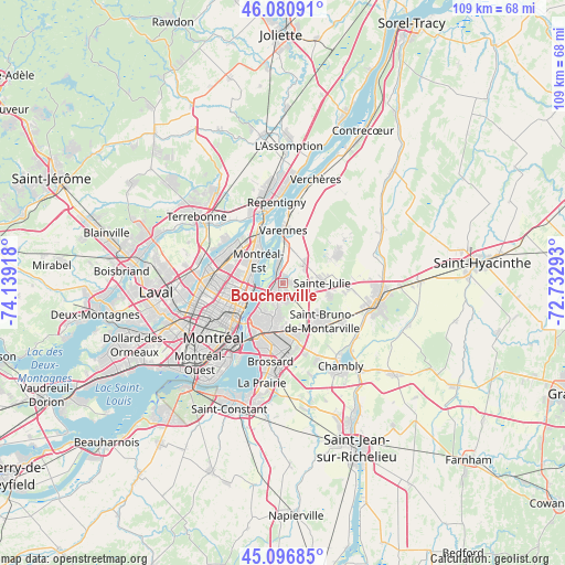
Boucherville GPS coordinates[2]
45° 35' 27.744" North, 73° 26' 9.78" West
| Map corner | latitude | longitude |
|---|---|---|
| Upper-left | 46.08091°, | -74.13918° |
| Center: | 45.59104°, | -73.43605° |
| Lower-right: | 45.09685°, | -72.73293° |
| Map W x H: | 109.4×109.4 km | = 68×68mi |
| max Lat: | 73.03752° ⇑72.1% North |
| Boucherville: | 45.59104° |
| min Lat: | ⇓27.9% South 42.05009° |
| min Long | Boucherville | max Long |
| -139.43328° | -73.43605° | -52.70931° |
| W 68.9%⇐ | ⇒31.1% E |
Elevation
Elevation of Boucherville is 16 m = 52 ft, and this is 238.4 m = 782 ft below average elevation for this country.
| Max E: |
1518 m = 4980 ft | 89.1% |
| Avg. | 254.4 m = 835 ft | |
| Boucherville | 16 m = 52 ft | |
Min E: |
-2 m = -7 ft | 10.9% |
See also: Canada elevation on elevation.city.
Geographical zone
Boucherville is located in North temperate zone (between Tropic of Cancer and the Arctic Circle). Distance of this North polar circle is 2331.9 km =1449 mi to North.| Distance of | km | miles | from Boucherville |
|---|---|---|---|
| North Pole | 4937.8 | 3068.2 | to North |
| Arctic Circle | 2331.9 | 1449 | to North |
| Tropic Cancer | 2463.3 | 1530.6 | to South |
| Equator | 5069.2 | 3149.9 | to South |


Nearby cities:
15 places around Boucherville: (largest is in red/bold)
• Brossard
15.8 km =9.8 mi,  188°
188°
• Charlemagne
14.4 km =8.9 mi,  345°
345°
• Longueuil
9.2 km =5.7 mi,  223°
223°
• Montréal
14.9 km =9.3 mi,  232°
232°
• Montréal-Est
7.2 km =4.5 mi,  309°
309°
• Repentigny
16.8 km =10.4 mi,  356°
356°
• Saint-Amable
12.5 km =7.8 mi,  58°
58°
• Saint-Basile-le-Grand
13.6 km =8.5 mi,  118°
118°
• Saint-Bruno-de-Montarville
9.3 km =5.8 mi,  133°
133°
• Saint-Charles
15.5 km =9.6 mi,  323°
323°
• Saint-Léonard
12.4 km =7.7 mi,  268°
268°
• Saint-Michel
14.7 km =9.1 mi,  259°
259°
• Saint-Victor
6.6 km =4.1 mi,  289°
289°
• Sainte-Julie
8.1 km =5 mi,  96°
96°
• Varennes
10.3 km =6.4 mi,  1°
1°
Sources, notices
• [Note1] Compared only with cities in Canada existing in our database
• [Src1] Map data: © OpenStreetMap contributors (CC-BY-SA)
• [Src2] Other city data from geonames.org with taken over terms of usage.
• [Src3] Geographical zone / Annual Mean Temperature by Robert A. Rohde @ Wikipedia
