Sainte-Madeleine geodata
Sainte-Madeleine (Quebec) is a populated place; located in Canada in America/Toronto (GMT-4) time zone. With population of 1,959 people, there are 758 cities with bigger population in this country. Compared to other cities in Canada, 72.1% of cities are located further ↑North; 72% of cities are located further ←West and 81.3% of cities have higher elevation than Sainte-Madeleine. Note1


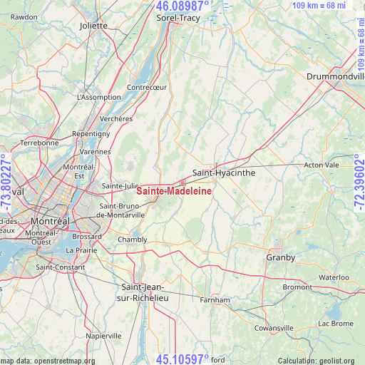
Sainte-Madeleine GPS coordinates[2]
45° 36' 0.288" North, 73° 5' 56.904" West
| Map corner | latitude | longitude |
|---|---|---|
| Upper-left | 46.08987°, | -73.80227° |
| Center: | 45.60008°, | -73.09914° |
| Lower-right: | 45.10597°, | -72.39602° |
| Map W x H: | 109.4×109.4 km | = 68×68mi |
| max Lat: | 73.03752° ⇑72.1% North |
| Sainte-Madeleine: | 45.60008° |
| min Lat: | ⇓27.9% South 42.05009° |
| min Long | Sainte-Madelein | max Long |
| -139.43328° | -73.09914° | -52.70931° |
| W 72%⇐ | ⇒28% E |
Elevation
Elevation of Sainte-Madeleine is 30 m = 98 ft, and this is 224.4 m = 736 ft below average elevation for this country.
| Max E: |
1518 m = 4980 ft | 81.3% |
| Avg. | 254.4 m = 835 ft | |
| Sainte-Madeleine | 30 m = 98 ft | |
Min E: |
-2 m = -7 ft | 18.7% |
See also: Canada elevation on elevation.city.
Geographical zone
Sainte-Madeleine is located in North temperate zone (between Tropic of Cancer and the Arctic Circle). Distance of this North polar circle is 2330.9 km =1448.4 mi to North.| Distance of | km | miles | from Sainte-Madeleine |
|---|---|---|---|
| North Pole | 4936.8 | 3067.6 | to North |
| Arctic Circle | 2330.9 | 1448.4 | to North |
| Tropic Cancer | 2464.3 | 1531.2 | to South |
| Equator | 5070.3 | 3150.5 | to South |


Nearby cities:
15 places around Sainte-Madeleine: (largest is in red/bold)
• Beloeil
9 km =5.6 mi,  246°
246°
• Marieville
19.3 km =12 mi,  195°
195°
• Mont-Saint-Hilaire
7.8 km =4.8 mi,  240°
240°
• Otterburn Park
11.7 km =7.3 mi,  230°
230°
• Richelieu
20.8 km =12.9 mi,  213°
213°
• Rougemont
18.9 km =11.7 mi,  168°
168°
• Saint-Amable
16.5 km =10.3 mi,  289°
289°
• Saint-Barnabé-Sud
19.9 km =12.4 mi,  43°
43°
• Saint-Basile-le-Grand
16.1 km =10 mi, 242°
• Saint-Bruno-de-Montarville
20.8 km =12.9 mi, 249°
• Saint-Damase
10.7 km =6.6 mi,  133°
133°
• Saint-Denis-sur-Richelieu
20.7 km =12.9 mi,  349°
349°
• Saint-Hyacinthe
11.6 km =7.2 mi,  72°
72°
• Saint-Pie
18.3 km =11.4 mi, 126°
• Sainte-Julie
18.2 km =11.3 mi,  264°
264°
Sources, notices
• [Note1] Compared only with cities in Canada existing in our database
• [Src1] Map data: © OpenStreetMap contributors (CC-BY-SA)
• [Src2] Other city data from geonames.org with taken over terms of usage.
• [Src3] Geographical zone / Annual Mean Temperature by Robert A. Rohde @ Wikipedia
