Saint-Victor geodata
Saint-Victor (Quebec) is a populated place; located in Canada in America/Toronto (GMT-4) time zone. With population of 1,233 people, there are 942 cities with bigger population in this country. Compared to other cities in Canada, 71.6% of cities are located further ↑North; 68.1% of cities are located further ←West and 88.3% of cities have higher elevation than Saint-Victor. Note1


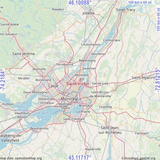
Saint-Victor GPS coordinates[2]
45° 36' 40.248" North, 73° 30' 54.972" West
| Map corner | latitude | longitude |
|---|---|---|
| Upper-left | 46.10088°, | -74.2184° |
| Center: | 45.61118°, | -73.51527° |
| Lower-right: | 45.11717°, | -72.81215° |
| Map W x H: | 109.4×109.4 km | = 68×68mi |
| max Lat: | 73.03752° ⇑71.6% North |
| Saint-Victor: | 45.61118° |
| min Lat: | ⇓28.4% South 42.05009° |
| min Long | Saint-Victor | max Long |
| -139.43328° | -73.51527° | -52.70931° |
| W 68.1%⇐ | ⇒31.9% E |
Elevation
Elevation of Saint-Victor is 17 m = 56 ft, and this is 237.4 m = 779 ft below average elevation for this country.
| Max E: |
1518 m = 4980 ft | 88.3% |
| Avg. | 254.4 m = 835 ft | |
| Saint-Victor | 17 m = 56 ft | |
Min E: |
-2 m = -7 ft | 11.7% |
See also: Canada elevation on elevation.city.
Geographical zone
Saint-Victor is located in North temperate zone (between Tropic of Cancer and the Arctic Circle). Distance of this North polar circle is 2329.7 km =1447.6 mi to North.| Distance of | km | miles | from Saint-Victor |
|---|---|---|---|
| North Pole | 4935.6 | 3066.8 | to North |
| Arctic Circle | 2329.7 | 1447.6 | to North |
| Tropic Cancer | 2465.6 | 1532.1 | to South |
| Equator | 5071.5 | 3151.3 | to South |


Nearby cities:
15 places around Saint-Victor: (largest is in red/bold)
• Boucherville
6.6 km =4.1 mi,  109°
109°
• Charlemagne
12 km =7.5 mi,  12°
12°
• Laval
14.5 km =9 mi,  251°
251°
• Longueuil
8.9 km =5.5 mi,  181°
181°
• Mont-Royal
14.8 km =9.2 mi,  224°
224°
• Montréal
12.7 km =7.9 mi,  206°
206°
• Montréal-Est
2.4 km =1.5 mi, 14°
• Repentigny
15.4 km =9.6 mi,  19°
19°
• Saint-Bruno-de-Montarville
15.6 km =9.7 mi,  123°
123°
• Saint-Charles
10.6 km =6.6 mi,  343°
343°
• Saint-Léonard
6.7 km =4.2 mi, 247°
• Saint-Michel
9.6 km =6 mi,  239°
239°
• Sainte-Julie
14.6 km =9.1 mi,  102°
102°
• Terrebonne
14.2 km =8.8 mi,  313°
313°
• Varennes
10.3 km =6.4 mi,  38°
38°
Sources, notices
• [Note1] Compared only with cities in Canada existing in our database
• [Src1] Map data: © OpenStreetMap contributors (CC-BY-SA)
• [Src2] Other city data from geonames.org with taken over terms of usage.
• [Src3] Geographical zone / Annual Mean Temperature by Robert A. Rohde @ Wikipedia
