Saint-Pie geodata
Saint-Pie (Quebec) is a seat of a third-order administrative division; located in Canada in America/Toronto (GMT-4) time zone. With population of 5,438 people, there are 455 cities with bigger population in this country. Compared to other cities in Canada, 74.4% of cities are located further ↑North; 72.9% of cities are located further ←West and 77.1% of cities have higher elevation than Saint-Pie. Note1


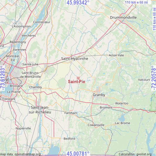
Saint-Pie GPS coordinates[2]
45° 30' 9.972" North, 72° 54' 32.04" West
| Map corner | latitude | longitude |
|---|---|---|
| Upper-left | 45.99342°, | -73.61203° |
| Center: | 45.50277°, | -72.9089° |
| Lower-right: | 45.00781°, | -72.20578° |
| Map W x H: | 109.6×109.6 km | = 68.1×68.1mi |
| max Lat: | 73.03752° ⇑74.4% North |
| Saint-Pie: | 45.50277° |
| min Lat: | ⇓25.6% South 42.05009° |
| min Long | Saint-Pie | max Long |
| -139.43328° | -72.9089° | -52.70931° |
| W 72.9%⇐ | ⇒27.1% E |
Elevation
Elevation of Saint-Pie is 38 m = 125 ft, and this is 216.4 m = 710 ft below average elevation for this country.
| Max E: |
1518 m = 4980 ft | 77.1% |
| Avg. | 254.4 m = 835 ft | |
| Saint-Pie | 38 m = 125 ft | |
Min E: |
-2 m = -7 ft | 22.9% |
See also: Canada elevation on elevation.city.
Geographical zone
Saint-Pie is located in North temperate zone (between Tropic of Cancer and the Arctic Circle). Distance of this North polar circle is 2341.7 km =1455.1 mi to North.| Distance of | km | miles | from Saint-Pie |
|---|---|---|---|
| North Pole | 4947.6 | 3074.3 | to North |
| Arctic Circle | 2341.7 | 1455.1 | to North |
| Tropic Cancer | 2453.5 | 1524.5 | to South |
| Equator | 5059.4 | 3143.8 | to South |


Nearby cities:
15 places around Saint-Pie: (largest is in red/bold)
• Ange-Gardien
17.1 km =10.6 mi,  186°
186°
• Beloeil
24.2 km =15 mi,  287°
287°
• Farnham
25.1 km =15.6 mi, 193°
• Granby
17.9 km =11.1 mi,  129°
129°
• Marieville
21.5 km =13.4 mi,  248°
248°
• Mont-Saint-Hilaire
22.7 km =14.1 mi, 287°
• Otterburn Park
24.2 km =15 mi,  278°
278°
• Richelieu
27.1 km =16.8 mi,  255°
255°
• Rougemont
13.4 km =8.3 mi,  234°
234°
• Saint-Barnabé-Sud
25.3 km =15.7 mi,  357°
357°
• Saint-Césaire
11.9 km =7.4 mi,  216°
216°
• Saint-Damase
7.8 km =4.8 mi,  295°
295°
• Saint-Hyacinthe
14.7 km =9.1 mi,  345°
345°
• Saint-Liboire
20 km =12.4 mi,  34°
34°
• Sainte-Madeleine
18.3 km =11.4 mi,  306°
306°
Sources, notices
• [Note1] Compared only with cities in Canada existing in our database
• [Src1] Map data: © OpenStreetMap contributors (CC-BY-SA)
• [Src2] Other city data from geonames.org with taken over terms of usage.
• [Src3] Geographical zone / Annual Mean Temperature by Robert A. Rohde @ Wikipedia
