Saint-Émile-de-Suffolk geodata
Saint-Émile-de-Suffolk (Quebec) is a populated place; located in Canada in America/Toronto (GMT-4) time zone. With population of 566 people, there are 1160 cities with bigger population in this country. Compared to other cities in Canada, 64.8% of cities are located further ↑North; 58.2% of cities are located further ←West and 57.8% of cities have lower elevation than Saint-Émile-de-Suffolk. Note1


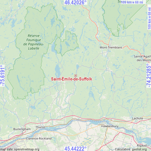
Saint-Émile-de-Suffolk GPS coordinates[2]
45° 56' 0.24" North, 74° 54' 57.492" West
| Map corner | latitude | longitude |
|---|---|---|
| Upper-left | 46.42026°, | -75.6191° |
| Center: | 45.9334°, | -74.91597° |
| Lower-right: | 45.44222°, | -74.21285° |
| Map W x H: | 108.7×108.7 km | = 67.5×67.5mi |
| max Lat: | 73.03752° ⇑64.8% North |
| Saint-Émile-de-Suffolk: | 45.9334° |
| min Lat: | ⇓35.2% South 42.05009° |
| min Long | Saint-Émile-de | max Long |
| -139.43328° | -74.91597° | -52.70931° |
| W 58.2%⇐ | ⇒41.8% E |
Elevation
Elevation of Saint-Émile-de-Suffolk is 217 m = 712 ft, and this is 37.4 m = 123 ft below average elevation for this country.
| Max E: |
1518 m = 4980 ft | 42.2% |
| Avg. | 254.4 m = 835 ft | |
| Saint-Émile-de-Suffolk | 217 m = 712 ft | |
Min E: |
-2 m = -7 ft | 57.8% |
See also: Canada elevation on elevation.city.
Geographical zone
Saint-Émile-de-Suffolk is located in North temperate zone (between Tropic of Cancer and the Arctic Circle). Distance of this North polar circle is 2293.9 km =1425.4 mi to North.| Distance of | km | miles | from Saint-Émile-de-Suffolk |
|---|---|---|---|
| North Pole | 4899.7 | 3044.5 | to North |
| Arctic Circle | 2293.9 | 1425.4 | to North |
| Tropic Cancer | 2501.4 | 1554.3 | to South |
| Equator | 5107.3 | 3173.5 | to South |


Nearby cities:
15 places around Saint-Émile-de-Suffolk: (largest is in red/bold)
• Calumet
38.2 km =23.7 mi,  145°
145°
• Hawkesbury
43.8 km =27.2 mi, 147°
• L'Orignal
39 km =24.2 mi, 153°
• La Conception
29.3 km =18.2 mi,  34°
34°
• La Minerve
35.2 km =21.9 mi,  357°
357°
• Labelle
41.4 km =25.7 mi,  19°
19°
• Lac-Simon
28.3 km =17.6 mi, 28°
• Mont-Tremblant
40.2 km =25 mi,  39°
39°
• Montebello
31.5 km =19.6 mi,  182°
182°
• Notre-Dame-du-Mont-Carmel
15.9 km =9.9 mi,  305°
305°
• Papineauville
36 km =22.4 mi,  192°
192°
• Plantagenet
45 km =28 mi, 187°
• Saint-André-Avellin
26.7 km =16.6 mi,  205°
205°
• Saint-Faustin
39.2 km =24.4 mi,  58°
58°
• Wendover
43.3 km =26.9 mi,  202°
202°
Sources, notices
• [Note1] Compared only with cities in Canada existing in our database
• [Src1] Map data: © OpenStreetMap contributors (CC-BY-SA)
• [Src2] Other city data from geonames.org with taken over terms of usage.
• [Src3] Geographical zone / Annual Mean Temperature by Robert A. Rohde @ Wikipedia
