Labelle geodata
Labelle (Quebec) is a populated place; located in Canada in America/Toronto (GMT-4) time zone. With population of 1,239 people, there are 940 cities with bigger population in this country. Compared to other cities in Canada, 57.7% of cities are located further ↑North; 58.6% of cities are located further ←West and 58.8% of cities have lower elevation than Labelle. Note1


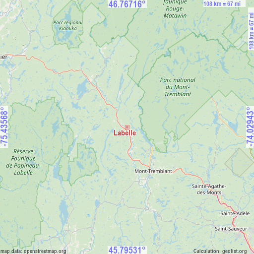
Labelle GPS coordinates[2]
46° 17' 0.204" North, 74° 43' 57.18" West
| Map corner | latitude | longitude |
|---|---|---|
| Upper-left | 46.76716°, | -75.43568° |
| Center: | 46.28339°, | -74.73255° |
| Lower-right: | 45.79531°, | -74.02943° |
| Map W x H: | 108.1×108.1 km | = 67.2×67.2mi |
| max Lat: | 73.03752° ⇑57.7% North |
| Labelle: | 46.28339° |
| min Lat: | ⇓42.3% South 42.05009° |
| min Long | Labelle | max Long |
| -139.43328° | -74.73255° | -52.70931° |
| W 58.6%⇐ | ⇒41.4% E |
Elevation
Elevation of Labelle is 223 m = 732 ft, and this is 31.4 m = 103 ft below average elevation for this country.
| Max E: |
1518 m = 4980 ft | 41.2% |
| Avg. | 254.4 m = 835 ft | |
| Labelle | 223 m = 732 ft | |
Min E: |
-2 m = -7 ft | 58.8% |
See also: Canada elevation on elevation.city.
Geographical zone
Labelle is located in North temperate zone (between Tropic of Cancer and the Arctic Circle). Distance of this North polar circle is 2254.9 km =1401.1 mi to North.| Distance of | km | miles | from Labelle |
|---|---|---|---|
| North Pole | 4860.8 | 3020.4 | to North |
| Arctic Circle | 2254.9 | 1401.1 | to North |
| Tropic Cancer | 2540.3 | 1578.5 | to South |
| Equator | 5146.2 | 3197.7 | to South |


Nearby cities:
15 places around Labelle: (largest is in red/bold)
• La Conception
15 km =9.3 mi,  170°
170°
• La Minerve
15.8 km =9.8 mi,  256°
256°
• Lac-Simon
14.1 km =8.8 mi,  182°
182°
• Mont-Tremblant
13.8 km =8.6 mi,  124°
124°
• Morin-Heights
56.6 km =35.2 mi,  138°
138°
• Notre-Dame-du-Mont-Carmel
40.1 km =24.9 mi,  222°
222°
• Rivière-Rouge
18 km =11.2 mi,  325°
325°
• Saint-Adolphe-d'Howard
46.8 km =29.1 mi, 138°
• Saint-Donat-de-Montcalm
39.4 km =24.5 mi,  84°
84°
• Saint-Faustin
26.7 km =16.6 mi,  133°
133°
• Saint-Émile-de-Suffolk
41.4 km =25.7 mi,  199°
199°
• Sainte-Adèle
59.3 km =36.8 mi, 128°
• Sainte-Agathe-des-Monts
43.3 km =26.9 mi, 126°
• Val-David
48.5 km =30.1 mi, 124°
• Val-Morin
52.8 km =32.8 mi, 126°
Sources, notices
• [Note1] Compared only with cities in Canada existing in our database
• [Src1] Map data: © OpenStreetMap contributors (CC-BY-SA)
• [Src2] Other city data from geonames.org with taken over terms of usage.
• [Src3] Geographical zone / Annual Mean Temperature by Robert A. Rohde @ Wikipedia
