Wendover geodata
Wendover (Ontario) is a populated place; located in Canada in America/Toronto (GMT-4) time zone. With population of 1,302 people, there are 920 cities with bigger population in this country. Compared to other cities in Canada, 72.6% of cities are located further ↑North; 57.6% of cities are located further ←West and 70.3% of cities have higher elevation than Wendover. Note1
Administrative division(s):
- Level 1: Ontario
- Level 2: Comtés unis de Prescott et Russell
- Level 3: Alfred and Plantagenet


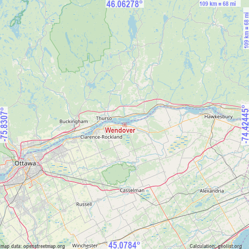
Wendover GPS coordinates[2]
45° 34' 21.9" North, 75° 7' 39.252" West
| Map corner | latitude | longitude |
|---|---|---|
| Upper-left | 46.06278°, | -75.8307° |
| Center: | 45.57275°, | -75.12757° |
| Lower-right: | 45.0784°, | -74.42445° |
| Map W x H: | 109.5×109.5 km | = 68×68mi |
| max Lat: | 73.03752° ⇑72.6% North |
| Wendover: | 45.57275° |
| min Lat: | ⇓27.4% South 42.05009° |
| min Long | Wendover | max Long |
| -139.43328° | -75.12757° | -52.70931° |
| W 57.6%⇐ | ⇒42.4% E |
Elevation
Elevation of Wendover is 54 m = 177 ft, and this is 200.4 m = 657 ft below average elevation for this country.
| Max E: |
1518 m = 4980 ft | 70.3% |
| Avg. | 254.4 m = 835 ft | |
| Wendover | 54 m = 177 ft | |
Min E: |
-2 m = -7 ft | 29.7% |
See also: Canada elevation on elevation.city.
Geographical zone
Wendover is located in North temperate zone (between Tropic of Cancer and the Arctic Circle). Distance of this North polar circle is 2334 km =1450.3 mi to North.| Distance of | km | miles | from Wendover |
|---|---|---|---|
| North Pole | 4939.8 | 3069.4 | to North |
| Arctic Circle | 2334 | 1450.3 | to North |
| Tropic Cancer | 2461.3 | 1529.4 | to South |
| Equator | 5067.2 | 3148.6 | to South |


Nearby cities:
15 places around Wendover: (largest is in red/bold)
• Bourget
15.6 km =9.7 mi,  186°
186°
• Buckingham
22.9 km =14.2 mi,  273°
273°
• Calumet
39.3 km =24.4 mi,  77°
77°
• Casselman
28.7 km =17.8 mi,  172°
172°
• Clarence-Rockland
13 km =8.1 mi,  258°
258°
• Fallingbrook
29.8 km =18.5 mi,  248°
248°
• Hawkesbury
39.9 km =24.8 mi,  85°
85°
• L'Orignal
34.3 km =21.3 mi, 81°
• Limoges
28.3 km =17.6 mi,  199°
199°
• Montebello
17.4 km =10.8 mi,  60°
60°
• Papineauville
10 km =6.2 mi, 60°
• Plantagenet
11.3 km =7 mi,  113°
113°
• Queenswood Heights
31.6 km =19.6 mi, 248°
• Saint-André-Avellin
16.7 km =10.4 mi,  16°
16°
• Thurso
9.9 km =6.2 mi,  287°
287°
Sources, notices
• [Note1] Compared only with cities in Canada existing in our database
• [Src1] Map data: © OpenStreetMap contributors (CC-BY-SA)
• [Src2] Other city data from geonames.org with taken over terms of usage.
• [Src3] Geographical zone / Annual Mean Temperature by Robert A. Rohde @ Wikipedia
