La Minerve geodata
La Minerve (Quebec) is a populated place; located in Canada in America/Toronto (GMT-4) time zone. With population of 1,234 people, there are 941 cities with bigger population in this country. Compared to other cities in Canada, 58.2% of cities are located further ↑North; 58.2% of cities are located further ←West and 68% of cities have lower elevation than La Minerve. Note1


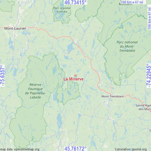
La Minerve GPS coordinates[2]
46° 15' 0.324" North, 74° 55' 57.252" West
| Map corner | latitude | longitude |
|---|---|---|
| Upper-left | 46.73415°, | -75.6357° |
| Center: | 46.25009°, | -74.93257° |
| Lower-right: | 45.76172°, | -74.22945° |
| Map W x H: | 108.1×108.1 km | = 67.2×67.2mi |
| max Lat: | 73.03752° ⇑58.2% North |
| La Minerve: | 46.25009° |
| min Lat: | ⇓41.8% South 42.05009° |
| min Long | La Minerve | max Long |
| -139.43328° | -74.93257° | -52.70931° |
| W 58.2%⇐ | ⇒41.8% E |
Elevation
Elevation of La Minerve is 280 m = 919 ft, and this is 25.6 m = 84 ft above average elevation for this country.
| Max E: |
1518 m = 4980 ft | 32% |
| La Minerve | 280 m 919 ft | |
| Avg. | 254.4 m = 835 ft | |
Min E: |
-2 m = -7 ft | 68% |
See also: Canada elevation on elevation.city.
Geographical zone
La Minerve is located in North temperate zone (between Tropic of Cancer and the Arctic Circle). Distance of this North polar circle is 2258.6 km =1403.4 mi to North.| Distance of | km | miles | from La Minerve |
|---|---|---|---|
| North Pole | 4864.5 | 3022.7 | to North |
| Arctic Circle | 2258.6 | 1403.4 | to North |
| Tropic Cancer | 2536.6 | 1576.2 | to South |
| Equator | 5142.5 | 3195.4 | to South |


Nearby cities:
15 places around La Minerve: (largest is in red/bold)
• Ferme-Neuve
63.8 km =39.6 mi,  321°
321°
• La Conception
21.1 km =13.1 mi,  121°
121°
• Labelle
15.8 km =9.8 mi,  76°
76°
• Lac-Simon
18 km =11.2 mi,  125°
125°
• Mont-Laurier
54.8 km =34.1 mi,  307°
307°
• Mont-Tremblant
27.1 km =16.8 mi,  98°
98°
• Notre-Dame-du-Mont-Carmel
28.4 km =17.6 mi,  204°
204°
• Rivière-Rouge
19.2 km =11.9 mi,  15°
15°
• Saint-Adolphe-d'Howard
56 km =34.8 mi, 124°
• Saint-André-Avellin
60.2 km =37.4 mi,  189°
189°
• Saint-Donat-de-Montcalm
55.2 km =34.3 mi, 82°
• Saint-Faustin
37.7 km =23.4 mi,  113°
113°
• Saint-Émile-de-Suffolk
35.2 km =21.9 mi,  177°
177°
• Sainte-Agathe-des-Monts
54.8 km =34.1 mi, 113°
• Val-David
60.2 km =37.4 mi, 113°
Sources, notices
• [Note1] Compared only with cities in Canada existing in our database
• [Src1] Map data: © OpenStreetMap contributors (CC-BY-SA)
• [Src2] Other city data from geonames.org with taken over terms of usage.
• [Src3] Geographical zone / Annual Mean Temperature by Robert A. Rohde @ Wikipedia
